Boston is getting a frigid blast this week, but there shouldn’t be much snow
Before the weekend storm was over, people were already talking about another round of precipitation coming on Tuesday. It still looks like there’s going to be a storm system coming Tuesday, but the good news for those of you that don’t want more wintry weather just yet is that the bulk of it is going to fall as rain.
Related Links
I often talk about the track of a storm system being incredibly important for the amount of snow we receive, but it’s also important for whether we end up on the warm or the cold side of a storm.
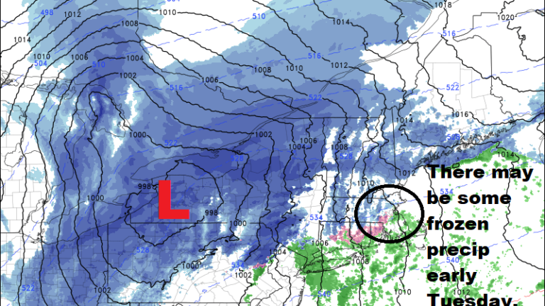
On Tuesday, a low-pressure area will move up through New England and stay to the west of Boston. The right side of low pressure areas have southerly winds, and this pulls in mild air or air from the ocean. This time of the year water temperatures are still well into the forties, so any trajectory of wind off the water will quickly change frozen precipitation to liquid.
However, because cold air is heavier and denser than warm air, sometimes the cold sticks around just long enough, as the precipitation begins, to cause some snow or freezing rain.
On Tuesday morning, those of you who live west of Route 495 have the greatest risk of some slick travel into work. This is a timing issue; if the warm air moves in quickly enough, then we won’t see any snow or freezing rain. But if it holds on for even just an hour or two, roads can quickly become hazardous.


No matter what happens Tuesday, this isn’t a big storm and the net effect will be a loss of snow, not a gain, because of the mild air. One thing the storm is going to do is pull down a blast of the coldest air of the season so far. Tuesday night and Wednesday everything will freeze rock solid, so although the snow will become quite slushy Tuesday, it will be like a brick Wednesday morning.

Temperatures both Wednesday and Thursday will average 10 to 15 degrees below normal. There could be a couple of snow showers Wednesday morning, but generally this should be a very dry air mass.
As the cold relaxes a bit on Friday, another low-pressure system will move up along the coast and threaten southern New England with more snow. I am using the word “threaten” because it is not a sure bet.
As a matter of fact, presently I would say we will miss the snowstorm, but it’s coming close enough that it’s not impossible that we will end up with accumulating snow sometime Friday. This is a five-day forecast, and things can dramatically change.
Whatever happens on Friday, there will be some modification of the cold heading into the weekend as temperatures get back into the 30s and even the lower 40s, which is about seasonable for this time of the year.