7 maps predicting snowfall totals Sunday through Monday
"The highest snow amounts still favor southeastern Mass., just inland from Route 3."
National Weather Service

By John Waller and Jack Pickell

Check out WHEN TO SHOVEL @boston25 #boston #newengland #Massachusetts #newhampshire pic.twitter.com/Kb8f7A12aA
— Shiri Spear (@ShiriSpear) February 23, 2026
Shifted zones south just a wee bit. Could see 2FT+ where mesoscale bands set up. Most likely in white zone. But… bands are tricky. Expect surprises. #Storm #Blizzard #Boston #Weather #Noreaster #springisstillcoming pic.twitter.com/CYQl5rIwGV
— Dave Epstein (@growingwisdom) February 23, 2026
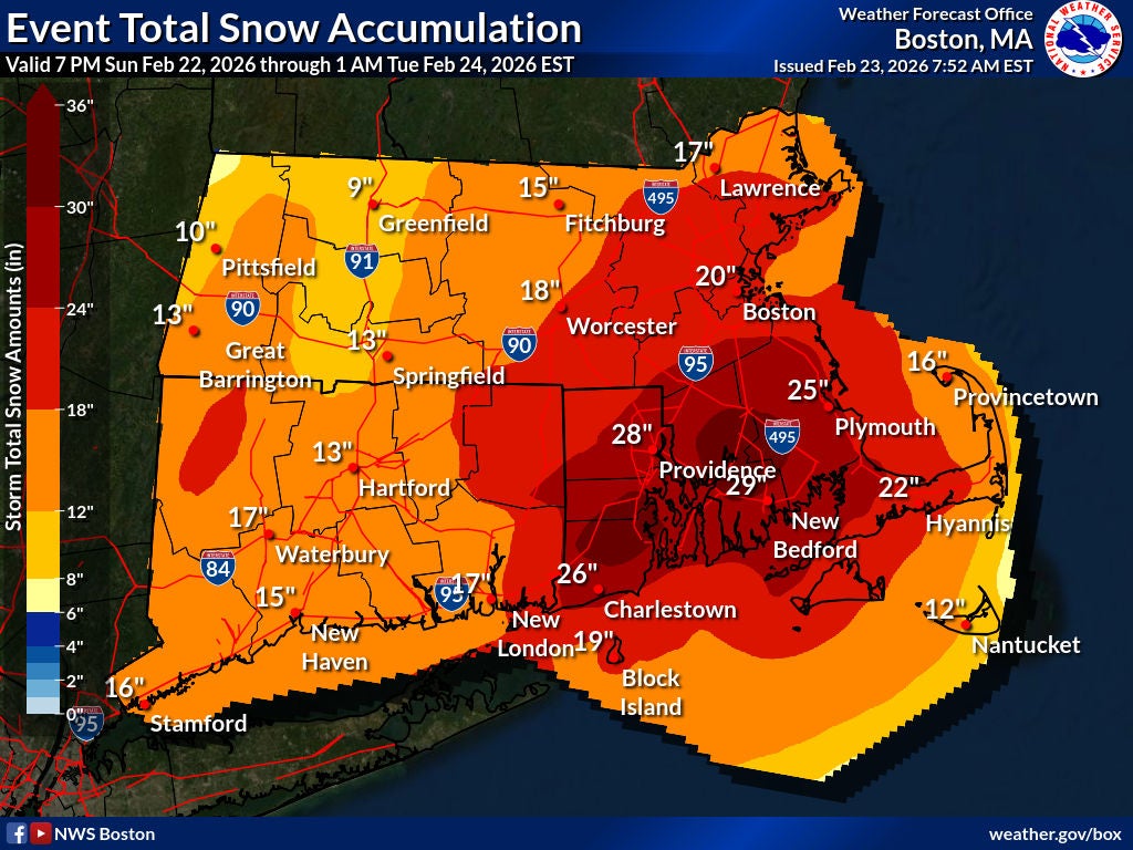
The highest snow amounts still favor southeastern Mass., just inland from Route 3. Big swaths of 18 to 24 inches will be found here, with some spots eclipsing 2 feet.https://t.co/La1qPfcJXr
— NBC10 Boston (@NBC10Boston) February 23, 2026
SUN 6pm: Blizzard inbound to the region late tonight through Monday night. Complete coverage tonight on @7News at 6/9/10/11 pic.twitter.com/6pzqGmgmpr
— Jeremy Reiner (@jreineron7) February 22, 2026
FINAL CALL SNOW MAP….the nowcasting begins. pic.twitter.com/oOfv1njLGI
— David Williams (@Wxdavidw) February 22, 2026
Trickiest part at this stage is forecasting banding. We still anticipate the highest amounts in SE Mass. With rapid rising motion in that band, there's always a "sinking" zone of drier air somewhere on the other side. But Boston south is the jackpot, and CT Valley the low spot pic.twitter.com/TtS1iS8XeQ
— Eric Fisher (@ericfisher) February 22, 2026
Stay up to date with everything Boston. Receive the latest news and breaking updates, straight from our newsroom to your inbox.
To comment, please create a screen name in your profile
To comment, please verify your email address
Conversation
This discussion has ended. Please join elsewhere on Boston.com