Winter Watch
❄️ Get winter weather alerts and snow maps, delivered to your inbox.
By Heather Alterisio and Dialynn Dwyer
A series of winter storms is set to impact Southern New England over the next week.
— NWS Boston (@NWSBoston) February 5, 2025
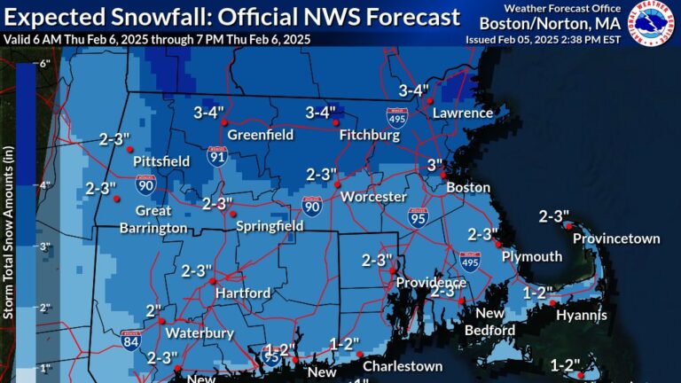
The first comes during the day on Thursday as snow moves in during the morning, dropping 1 to 4 inches of snow before flipping to sleet and freezing rain before coming to an end in the evening.❄️ pic.twitter.com/NmBs68cZ6b
The next winter storm comes Saturday night into early Sunday. Below is the probability of seeing at least 6 inches of snow >> pic.twitter.com/r5BX67WXpF
— NWS Boston (@NWSBoston) February 5, 2025
[Plowable snow later Sat night into Sun AM] There is high confidence that a plowable snow will impact #SNE later Sat night into Sun am. Attached is the latest model probability for 4" or more of snow across the region. pic.twitter.com/f5MRgro11I
— NWS Boston (@NWSBoston) February 5, 2025
[Winter Weather Timing] Snow rapidly overspreads the region between 7-10 am Thu. The snow may be briefly heavy with 2-3" in just a couple hours. Snow then changes to sleet/light freezing rain with diminishing intensity. Temps remain near or below freezing through Thu afternoon. pic.twitter.com/fowiDAp7sG
— NWS Boston (@NWSBoston) February 5, 2025
Quick burst of snow still looking to leave 1-3" for most of us tomorrow. A few 4" possible north of MA Pike and into southern NH/VT/ME. Arrives post am commute leaves pre evening commute. Trickiest travel 10am-3pm. Not a big event. pic.twitter.com/P4qKNLmqc3
— Dave Epstein (@growingwisdom) February 6, 2025
Quick burst of snow tomorrow then sleet and it ends as some freezing rain/drizzle with a light glazing. Good news is most of it occurs between commutes and school bus routes. #WeatherWisdom #Snow pic.twitter.com/qddA4wAwJI
— Dave Epstein (@growingwisdom) February 5, 2025
Good Thursday morning! Snow is on the way… but so is an icy mix of sleet and freezing rain. Snow fills in quickly 8-10am with a good burst thru noon- then it changes to an icy mix and rain in SE MA. Hazardous travel expected. More snow this weekend. Forecast on #WCVB pic.twitter.com/J18KY1AAYM
— Cindy Fitzgibbon (@Met_CindyFitz) February 6, 2025
THURSDAY BREAKDOWN…
— Cindy Fitzgibbon (@Met_CindyFitz) February 6, 2025
A quick burst of snow gives way to an icy mix
▶️Snow fills in 8-10am
▶️Snow, poor visibility, hazardous travel thru noon
▶️12-3pm change to sleet, FRZ rain and rain
▶️Precip tapers 4-6pm with an icy glaze on anything untreated making it slick esp. N&W#WCVB pic.twitter.com/vPzegMiXBu
Messy mix today. More snow Saturday night into Sunday morning. pic.twitter.com/TqymHx1ssw
— Chris Lambert (@clamberton7) February 6, 2025
Pattern is active. Another chance of snow Tuesday PM/Wednesday night week. pic.twitter.com/C97X28KZb8
— Chris Lambert (@clamberton7) February 6, 2025
Snowy Saturday night/Sunday am. Next storm has more moisture, bit farther south. Means more snow. At least several inches for most. Good shot of 6"+ where it's all snow if track stays consistent. pic.twitter.com/E7vYPm3ptD
— Chris Lambert (@clamberton7) February 6, 2025
Coating -1" near the south coast, 2-3" for Boston, MetroWest, souther/central Worcester County. 3-4" northern Mass/southern NH. Some sleet, then a glaze of ice too inland. pic.twitter.com/03nlJaGHDB
— Chris Lambert (@clamberton7) February 6, 2025
Heaviest precip tapers by 4pm, leftover coastal drizzle and freezing drizzle inland. pic.twitter.com/wTwq7POH26
— Chris Lambert (@clamberton7) February 6, 2025
Here comes the snow! Updates all day long on @NBC10Boston & on @NECN. General 2-4" across Boston today & along the Pike, less at the coast & southeast with ice mixing/changeover this afternoon. pic.twitter.com/r7senWk5AX
— Pamela Gardner NBC10 Boston (@Pamelanbcboston) February 6, 2025
Snow totals won't be spectacular, but it will be quite slick from late morning through the afternoon. @boston25 #mawx #nhwx #newengland pic.twitter.com/NfU9w85OzS
— Shiri Spear (@ShiriSpear) February 6, 2025
About the Saturday night – Sunday snow… All models have a widespread 6-10". Totals are not set, but it does look more impactful. Stay tuned! @boston25 pic.twitter.com/cPZF52WV4s
— Shiri Spear (@ShiriSpear) February 6, 2025
Morning! ❄️Snow fills in this morning, slippery travel results, some mixing south. A bigger storm arrives this weekend. Be sure to let us know what you end up with later today! https://t.co/hk2nRBZWsL pic.twitter.com/pV4gOqYxcz
— 1DegreeOutside (@1DegreeOutside) February 6, 2025
Haven't changed this map for tomorrow. I think most towns get 2-3", which falls in 2-3 hours for most locations before some mixing https://t.co/673tCEGga6
— Eric Fisher (@ericfisher) February 5, 2025
A quick couple inches falling tomorrow, topped with ice, will make for slippery roads. If there was a time to avoid traveling if you don't like driving in snow, 9am-2pm would be the window to avoid. #wbz pic.twitter.com/hdTP9alKg4
— Eric Fisher (@ericfisher) February 5, 2025
After tomorrow, the next storm in the pipeline looks juicier and snowier
— Eric Fisher (@ericfisher) February 5, 2025
Saturday overnight into Sunday morning. Solid moderate snowstorm pic.twitter.com/QgPrUmbMiv
❄️ Get winter weather alerts and snow maps, delivered to your inbox.
Stay up to date with everything Boston. Receive the latest news and breaking updates, straight from our newsroom to your inbox.
To comment, please create a screen name in your profile
To comment, please verify your email address
Conversation
This discussion has ended. Please join elsewhere on Boston.com