Bizarre snow strip over Kansas, just 15 miles across, highlights the challenges of forecasting
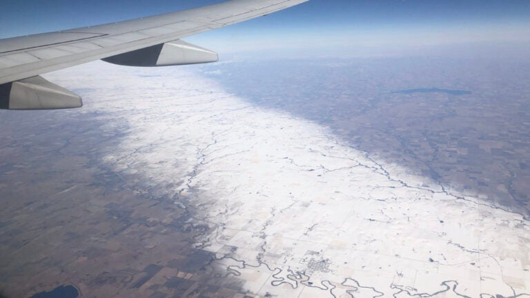
Leigh Marts was on her way from St. Louis to Phoenix on Wednesday when she spotted something unusual out the window of her Southwest Airlines flight: a narrow strip of white, flanked by bare grass, lay painted across the Kansas prairie below.
A similar sight was seen above Hutchinson, Kansas.
I saw this too, yesterday, en route from MSP to DFW. pic.twitter.com/LHLZhw1lxL
— Tracy Madejczyk (@tracymadejczyk) February 27, 2020
Weather satellites confirmed the bizarre feature, which highlights the meteorological caprice that can give rise to such narrow swaths of snow. More than a foot of snow fell in the band, which was 10 to 15 miles wide in places. Just a few miles on either side, there were hardly flurries.
Some incredible snow swaths over the Great Plains this afternoon. pic.twitter.com/1YVeXBLbQl
— Dakota Smith (@weatherdak) February 27, 2020
The thin stretch of intense snow was oriented northwest to southeast, passing through parts of Russell, Lincoln and Ellsworth counties in Kansas. The snow persisted toward Cottonwood Falls and Marion.
Flight data shows that Marts’ flight crossed over Interstate 70 heading west-southwest in the vicinity of Wilson and Dorrance, Kansas, a 15-minute car ride east of Russell and about 40 minutes northeast of Great Bend. Waconda Lake, just west of Beloit and Glen Elder, is visible in the distance.
The view on I-70 in Kansas within and just outside the narrow band of very heavy snow sitting west of Salina.
These cameras are less than 20 miles apart! pic.twitter.com/4mR2vczMYZ
— Greg Diamond (@gdimeweather) February 25, 2020
Meteorologists have long vented about the challenges of prediction when it comes to difficult winter storm forecasts. But Tuesday’s hyperlocal snow band was a step beyond what most Great Plains forecasters are accustomed to.
Snow bands such as this are generated by processes on the mesoscale, or local, level. That means that unlike with large sprawling storm systems that can be spotted by weather models days in advance, it’s often impossible to predict snow totals until the flakes are flying.
An intense snowfall band slowly moved across Central Kansas Tuesday, producing up to 13″ of snow! Based on satellite, the snowfall band was only 10-15 miles wide. #kswx pic.twitter.com/fxgDFcd4UG
— NWS Topeka (@NWSTopeka) February 26, 2020
Integral to its formation was convergence, or the gentle collision of two air masses at the surface. The “pileup” of air causes it to rise, blossoming into a band of heavy snow showers. That can also cut back on precipitation outside the band, since air exiting the clouds is likely to sink and choke off any snowfall on either side of the axis of best convergence.
The National Weather Service in Wichita did issue a winter storm warning once it became apparent that snowfall amounts would reach warning criteria.
Hyper-localized swaths of snow are a common occurrence within lake-effect snow bands; amounts taper off quickly outside the lone, stout snow band.
One such band brought 88 inches of snow to parts of Erie County, New York, on Nov. 15-21, 2014. More than five feet fell east of Buffalo between Nov. 17 and 19. Several feet of snow fell at the intersection of Transit Road and Walden Avenue in Depew, while Genesee Street, two miles to the north, saw only a couple of inches.


To comment, please create a screen name in your profile
To comment, please verify your email address
Conversation
This discussion has ended. Please join elsewhere on Boston.com