Newsletter Signup
Stay up to date on all the latest news from Boston.com
By John Waller
[635 AM] Dangerous situation early this morning near and southeast of the I-95 corridor. Winds gusting over Hurricane Force across southeast MA. Numerous downed trees and over 400K power outages in MA alone. TRAVEL IS NOT RECOMMENDED early this morning in southeast MA. pic.twitter.com/Hx5zjVKcd6
— NWS Boston (@NWSBoston) October 27, 2021
Highest wind gust for the storm: 94 mph in Edgartown at the Chappy Ferry dock at 4:31 am! #MAwx
— NWS Boston (@NWSBoston) October 27, 2021
Center of the storm was drifting S of Nantucket at 5 am. Window for strongest winds/damage continues along immediate coast until 7-8 am with somewhat lesser winds farther inland. Winds slowly diminish today but it remains windy. #CTwx #MAwx #RIwx pic.twitter.com/WCzV77yWyJ
— NWS Boston (@NWSBoston) October 27, 2021
Bomb Cyclone!
— NWS Boston (@NWSBoston) October 27, 2021
The pressure on Nantucket (KACK) dropped 28 mb over the past 24 hours (1008 mb to 980 mb) which meets the criteria for a bomb cyclone (drop of 24 mb or more in 24 hours).
Last bomb cyclone? October 17, 2019.
As of 6:30 AM, power outages of over 407,000 customers.
— MEMA (@MassEMA) October 27, 2021
Avoid downed power lines, check on neighbors, & use generators outside away from buildings.
Power outage safety tips: https://t.co/xmF3OzZnJh
Outage tracking map: https://t.co/tKdER1Llac pic.twitter.com/5gazyg0umB
A downward trend in wind gust strength is expected through the day… #WBZ #CBSNBoston pic.twitter.com/B9uTePWwDN
— Sarah Wroblewski (@sarahwroblewski) October 27, 2021
Unfortunate to see a lot of observation sites go missing during this storm… #WBZ #CBSNBoston #CurrentWindGusts pic.twitter.com/lXc0nG0N2Q
— Sarah Wroblewski (@sarahwroblewski) October 27, 2021
The stronger the winds, the higher the seas… as winds subside, so will the wave heights… but still currently the sea is angry this morning. 12' to 26' waves in our coastal water. #WBZ #CBSNBoston pic.twitter.com/1e6FD3Fkj7
— Sarah Wroblewski (@sarahwroblewski) October 27, 2021
With such huge waves… why not more coastal flooding?
— Sarah Wroblewski (@sarahwroblewski) October 27, 2021
We are LUCKY… tides are astronomically low, meaning lowest of the month. With a 3.5ft storm surge, only minor coastal flooding has been reported. If this were a week from now, we'd have major flooding. #WBZ #CBSNBoston pic.twitter.com/4Iw4UJd4PJ
Earlier this morning, a bouy reported a wave height of 32 ft, for nearly 3 hours… Incredible. The Green Monster at @Fenwaypark is 37 ft! #WBZ #CBSNBoston pic.twitter.com/tu0eQRNptc
— Sarah Wroblewski (@sarahwroblewski) October 27, 2021
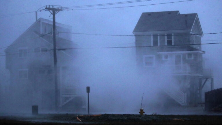
Most damage/wind reports are clustered in exposed coastal locations… longer duration of stronger gusts with no obstructions over the coastal waters. #WBZ #CBSNBoston pic.twitter.com/7WQGEyJk6h
— Sarah Wroblewski (@sarahwroblewski) October 27, 2021
We officially have Bombogenesis (rapid intensification) with this Nor'Easter…
— Sarah Wroblewski (@sarahwroblewski) October 27, 2021
The pressure dropped 28 mb in 24 hours in Nantucket… last Bomb Cyclone was nearly 2 years ago. #WBZ #CBSBoston pic.twitter.com/NGA1Bmty9i
As storm pulls away… still watching for some pockets of minor coastal flooding/Splashover later today. pic.twitter.com/epNqEiydrG
— Sarah Wroblewski (@sarahwroblewski) October 27, 2021
Despite the core of the strongest wind/rain behind us… expect slow travel improvements. roads are still covered with leaves, pine needles, and trees branches/limbs… plus many communities are without power, so traffic lights will be out. #WBZ #CBSNBoston pic.twitter.com/hJOpKAJhPp
— Sarah Wroblewski (@sarahwroblewski) October 27, 2021
Our nor'easter underwent #bombogenesis – resulting in gusts up to 94 mph in Massachusetts. The local forecast continues on @boston25 until 11 AM. pic.twitter.com/QZblPyNwvR
— Shiri Spear (@ShiriSpear) October 27, 2021
Some local roads are in horrible shape in eastern MA. Keep in mind, clean up may have to wait until the afternoon when damaging wind gusts finally subside. @boston25 #mawx pic.twitter.com/KbWBCLv3L4
— Shiri Spear (@ShiriSpear) October 27, 2021
This. Is. Nuts.#wind #nor'easter #bombcyclone #bombogenesis @boston25 pic.twitter.com/IjkeRxwggH
— Shiri Spear (@ShiriSpear) October 27, 2021
We have a windy & wet day on tap in #Boston. Expect the worst of it this morning. @boston25 #mawx pic.twitter.com/vmzlRI7ULy
— Shiri Spear (@ShiriSpear) October 27, 2021
We have some BIG waves at the coast right now. Splashover & minor coastal flooding expected this morning & afternoon… #mawx @boston25 pic.twitter.com/eIPBpsjsXA
— Shiri Spear (@ShiriSpear) October 27, 2021
80-90mph gusts earlier this morning as powerhouse storm slowly tapers off through the day. pic.twitter.com/7IOlZsoZF5
— Chris Lambert (@clamberton7) October 27, 2021
Breezy and cool tomorrow, best bet for some sun will be northwest of I-95. pic.twitter.com/wmg8RrQmIS
— Chris Lambert (@clamberton7) October 27, 2021
Cool and windy through the day with showers lingering through the afternoon, but the bulk of the rain will be over by then. pic.twitter.com/RrDajuoU28
— Chris Lambert (@clamberton7) October 27, 2021
Still breezy this evening, but the bulk of the damaging winds taper off this afternoon. pic.twitter.com/JBAbbhnOiG
— Chris Lambert (@clamberton7) October 27, 2021
Strongest winds for a couple more hours, but still gusts 50-60mph across the Cape late this morning. pic.twitter.com/QUmE7jCy9F
— Chris Lambert (@clamberton7) October 27, 2021
Very fortunate about tides being astronomical on the low side. Able to mitigate quite a bit of the 3-4 foot storm surge. If tides were running 2-3 feet higher like a couple weeks ago, coastal flooding would have been major for a lot of eastern Mass. pic.twitter.com/4alOt4Zkrn
— Chris Lambert (@clamberton7) October 27, 2021
Coastal flood advisory through today. Next high tide around 5pm. pic.twitter.com/jfjqdTYMC9
— Chris Lambert (@clamberton7) October 27, 2021
1-3" of rain for many locations so far. pic.twitter.com/bgcHjXXEdC
— Chris Lambert (@clamberton7) October 27, 2021
24-28 foot seas offshore, report of 32 foot seas at Gloucester Buoy. pic.twitter.com/gPEPlIrIaY
— Chris Lambert (@clamberton7) October 27, 2021
94mph gust in Edgartown on Martha's Vineyard pic.twitter.com/ec8SzVeO16
— Chris Lambert (@clamberton7) October 27, 2021
FORECAST WIND GUSTS…
— Cindy Fitzgibbon (@Met_CindyFitz) October 27, 2021
Strongest winds gusts in the Boston area thru 8am. Gusts will remain >40mph thru midday then step down SLOWLY this afternoon. Slower process with stronger winds in SE MA #WCVB pic.twitter.com/hhLTAGJChN
6AM WIND GUSTS …
— Cindy Fitzgibbon (@Met_CindyFitz) October 27, 2021
Still gusting over 50 and 60mph #WCVB pic.twitter.com/LASjIWTpTw
DAMAGING WINDS…
— Cindy Fitzgibbon (@Met_CindyFitz) October 27, 2021
Overnight winds gusted to hurricane force. Over 80 and 90mph!! Peak gust 94mph in Edgartown at the Chappy Ferry at 4:30am #WCVB pic.twitter.com/UZoSuwZaOT
Good Wednesday morning!
— Cindy Fitzgibbon (@Met_CindyFitz) October 27, 2021
Our 1st nor'easter of the season is not letting up this morning- lots of damage overnight. Still dealing with howling winds and rain. SLOW ramp down today. Team coverage and forecast details on #WCVB now pic.twitter.com/zjzafFyukG
TUESDAY AM weather update ⤵️
— Cindy Fitzgibbon (@Met_CindyFitz) October 26, 2021
🚨 1st nor’easter of the season brings rain and strong winds into tomorrow. Strongest winds overnight with the risk of power outages #WCVB pic.twitter.com/HNrbCcCVFe
John Waller is a deputy editor overseeing news coverage on Boston.com. He is a Lexington native and Colby College graduate.
Stay up to date on all the latest news from Boston.com
Stay up to date with everything Boston. Receive the latest news and breaking updates, straight from our newsroom to your inbox.
To comment, please create a screen name in your profile
To comment, please verify your email address
Conversation
This discussion has ended. Please join elsewhere on Boston.com