Some parts of Mass. will see up to 18 inches of snow
"In some areas, the snow will fall at 2 inches per hour, yielding half a foot in a very short period of time."
Related Links
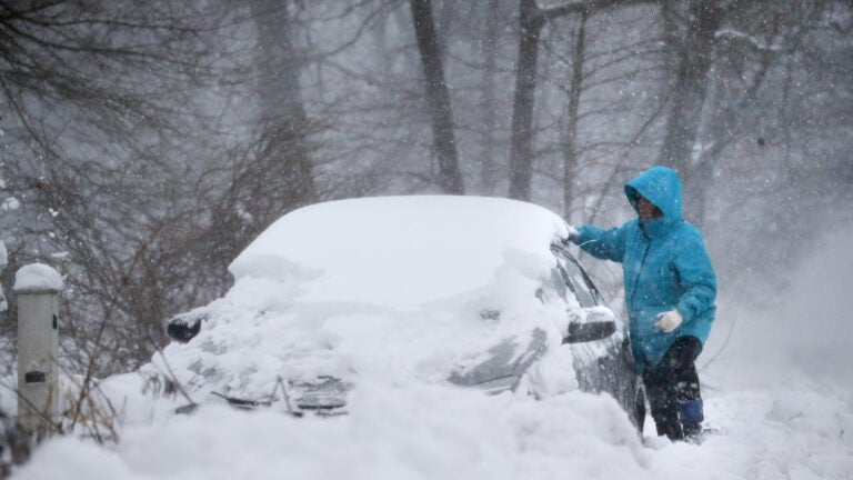
Today’s storm system is currently moving right on schedule, with snow moving through the area before a main thrust of heavier bands this afternoon. There could be several inches of snow on the ground by early afternoon, especially the further south you are. The high snowfall rate will move north after that. I recommend being off the roads this afternoon before conditions deteriorate.
How hard will it snow?
In some areas, the snow will fall at 2 inches per hour, yielding half a foot in a very short period of time. This will make any travel very difficult. Winds will increase this afternoon and become quite gusty. Since temperatures are going to be at or a little above freezing, plus wind, the biggest issue I see is the chance of power outages. This could be particularly exacerbated in areas that receive the heaviest and wettest snow.
Late morning through early afternoon the snow will pick up intensity. Expect 1-2 inch/hr snow rates thereafter into the evening. pic.twitter.com/bdUoPpuyRu
— Dave Epstein (@growingwisdom) February 1, 2021
Wondering if this could become a blizzard?
A blizzard is a storm with a visibility issue with quarter-mile visibility and winds 35 miles per hour or higher for three consecutive hours. Although we may see some blizzard-like conditions, especially along the coastline, I don’t expect this storm to be an official blizzard.
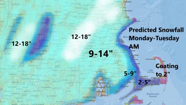
How much snow can you expect in your area?
Looking at the snow map below, you’ll see a range of expected snowfall for Massachusetts of 9 to 18 inches. As warmer air moves up the coastline, the snow will change to rain, so I’ve lowered my forecasted snowfall for Cape Cod. Notice a tremendous gradient from the tip of Cape Ann. If you live within 5 to perhaps 10 miles of the coastline, you should expect snowfall amounts to vary significantly. If the warm air comes in just a little bit earlier, it could limit the snowfall in these areas. Conversely, if the cold air holds on just a little bit longer, people who live here could receive significant snowfall and end up shoveling a lot more after all.
Not much change from Sunday in terms of the snow map. Those of you within 10 miles of the shore should expect the snow totals to still possibly vary from what I have here. The heaviest could end up further east and conversely the lighter a bit more inland. pic.twitter.com/weQ6NIuBgH
— Dave Epstein (@growingwisdom) February 1, 2021
When will the heaviest part of the storm end?
I expect most of the accumulating snow to come to an end between 7 and 11 p.m. from the South Shore to Greater Boston. It will go a little longer as you move north of Route 2, but even there the heaviest part of the storm will be over around midnight.
Will there be coastal flooding?
Coastal flooding will be minor, but some short roads are likely going to be closed at the time of high tide later this evening. There could be additional minor flooding Tuesday at the time of high tide.
This is a very slow-moving storm, and the upper levels of the atmosphere will spawn another low-pressure area in the Gulf of Maine Tuesday. This means a chance for some light precipitation in the forecast through Tuesday evening. In these situations, we can occasionally see another batch of snow rotating through the area. If this happens, it would mean an additional coating of an inch or two of snow Tuesday evening.
The clouds will hang tough on Wednesday, and there actually could be some more snow showers. The good news: by Thursday, sunshine will return with seasonably chilly temperatures.
Get Boston.com's browser alerts:
Enable breaking news notifications straight to your internet browser.


To comment, please create a screen name in your profile
To comment, please verify your email address
Conversation
This discussion has ended. Please join elsewhere on Boston.com