What meteorologists are saying about the remaining snow forecast for Thursday
“Please stay home.”
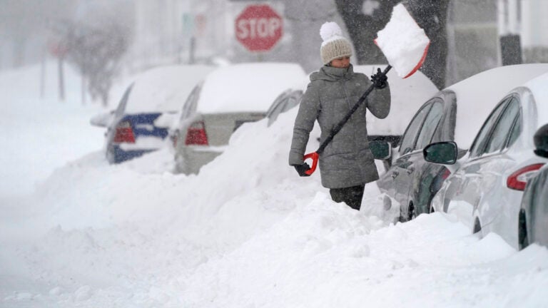
Massachusetts will continue to see heavy snow, strong winds, and minor coastal flooding Thursday from a coastal storm that began steadily blanketing the region overnight.
Related Links
The majority of the state remains under a Winter Storm Warning from the National Weather Service.
“This storm system will pull away from Southern New England later this afternoon and into tonight,” service meteorologists said Thursday morning.
Forecasters predicted most of the state could see around a foot of snow from the “significant, multifaceted winter storm” by the time it is over.
“We continue to have multiple weather-related concerns specific to this winter storm,” the service said. “Accumulating snowfall is one of them. Rapidly falling temperatures and a related flash freeze of snow/slush is looking likely later this morning across the South Shore into southeastern MA. This may extend as far north as the Boston metro area, potentially affecting I-95/Route 128 and the Southeast Expressway. Strong northeast winds and minor coastal flooding are other concerns.”
Below, what local meteorologists are saying about what the storm has delivered to Massachusetts so far — and what else to expect as the nor’easter continues.
National Weather Service: ‘Moderate to heavy snowfall was ongoing across most of southern New England early this morning’
Moderate to heavy snowfall was ongoing across most of southern New England early this morning. The darker blue band along the MA/CT/RI border east across southeast MA was producing snowfall rates of 2-3 inches per hour. pic.twitter.com/zZVMYnRn91
— NWS Boston (@NWSBoston) December 17, 2020
Here’s a look at what’s fallen as of 8 AM (more snow to come). Check out the real time map for yourself here–>https://t.co/NujEEYf5lL pic.twitter.com/h7ALu50rx9
— NWS Boston (@NWSBoston) December 17, 2020
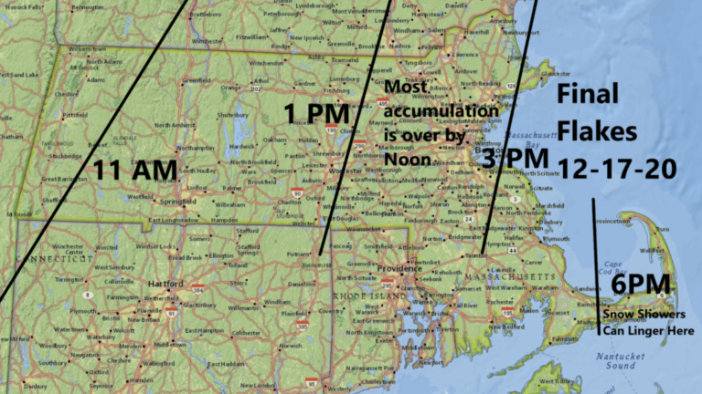
David Epstein: ‘The warm air at the coast will prevent southern beach communities from seeing the big totals, but you will still see more accumulation before it ends midday’
Most of the accumulation is over by 11 am in greater Boston, with a coating to a couple of inches after. These times are for those who don’t like to do anything until final flakes. Give me some wiggle room here, please. pic.twitter.com/Fb6rfxOe0G
— Dave Epstein (@growingwisdom) December 17, 2020
The warm air at the coast will prevent southern beach communities from seeing the big totals, but you will still see more accumulation before it ends midday. Tweaked the area around Situate etc. It’s not over. Still a significant band in that area. It’s not exact of course. pic.twitter.com/Y4qaDBcdMA
— Dave Epstein (@growingwisdom) December 17, 2020
Cindy Fitzgibbon, WCVB: ‘Intense snow bands the past few hours have produced 9″+ snow in parts of central MA. Heavy snow, strong winds and poor visibility thru the morning.’
Good Thursday morning…
We are in the worst of our nor’easter now. Intense snow bands the past few hours have produced 9″+ snow in parts of central MA. Heavy snow, strong winds and poor visibility thru the morning. Hunker down and join us for the latest on #WCVB starting at 4am pic.twitter.com/vBkEjYrv3x— Cindy Fitzgibbon (@Met_CindyFitz) December 17, 2020
8:25am UPDATE…
Bit of a ‘snowhole’ from Worcester into the Merrimack Valley with heavier snow bands to the east and west. Snow will taper after midday especially away from the coast. Turn on #WCVB now for storm details pic.twitter.com/ddf3phjcG0— Cindy Fitzgibbon (@Met_CindyFitz) December 17, 2020
Chris Gloninger, NBC10 Boston & NECN: ‘Please drive carefully’
‼️ FLASH FREEZE happening *NOW* 35 in Norwood at 6 AM, now 25! Please drive carefully. @nbc10boston @necn pic.twitter.com/AmiGRacEcI
— Chris Gloninger, CCM, CBM (@ChrisGloninger) December 17, 2020
1/2 vis = moderate snow. I’d say 0.5″ – 1.5″/hr rates happening here. Will likely continue through at least 11 AM. pic.twitter.com/oeyoILRlTh
— Chris Gloninger, CCM, CBM (@ChrisGloninger) December 17, 2020
Chris Lambert, 7News: ‘8-12″ across a good portion of the area already on the ground’
Tour de snow… 8-12″ across a good portion of the area already on the ground. pic.twitter.com/Nv3UcYaKFS
— Chris Lambert (@clamberton7) December 17, 2020
Slice of drier air near and northwest of 495. Patchy light snow now there, but snow’s much heavier near Boston. pic.twitter.com/xeXjkkXCdX
— Chris Lambert (@clamberton7) December 17, 2020
Shiri Spear, Boston 25 News: ‘Please stay home. The roads are bad. There’s a ton of snow coming. ’
Please stay home. The roads are bad. There’s a ton of snow coming. Be safe. @boston25 pic.twitter.com/HDCrsWPrIl
— Shiri Spear (@ShiriSpear) December 17, 2020
These snow totals are rising so quickly! Keep ’em coming! @boston25 pic.twitter.com/sJOMiEA2JA
— Shiri Spear (@ShiriSpear) December 17, 2020
Zack Green, WBZ: ‘There may be some minor flooding near today’s afternoon high tide’
No escaping how bad the roads will be today. If you can stay off the roads, please do! pic.twitter.com/OjxC1NgSX0
— Zack Green (@zackgreenwx) December 17, 2020
40+mph gusts at the coast this morning. Combine this with the light, airy snow and visibility drops off towards a 1/4-mile. Adding to the travel concern. pic.twitter.com/qagNNJINsd
— Zack Green (@zackgreenwx) December 17, 2020
Not a major concern but there may be some minor flooding near today’s afternoon high tide. Focus will be on those typically prone low laying spots. pic.twitter.com/HN3DJDHXUU
— Zack Green (@zackgreenwx) December 17, 2020

Get Boston.com's browser alerts:
Enable breaking news notifications straight to your internet browser.


To comment, please create a screen name in your profile
To comment, please verify your email address
Conversation
This discussion has ended. Please join elsewhere on Boston.com