What forecasters are saying about Tuesday’s storm
Here’s the latest from local meteorologists on when to expect the worst of the storm and what it will be like.
Related Links
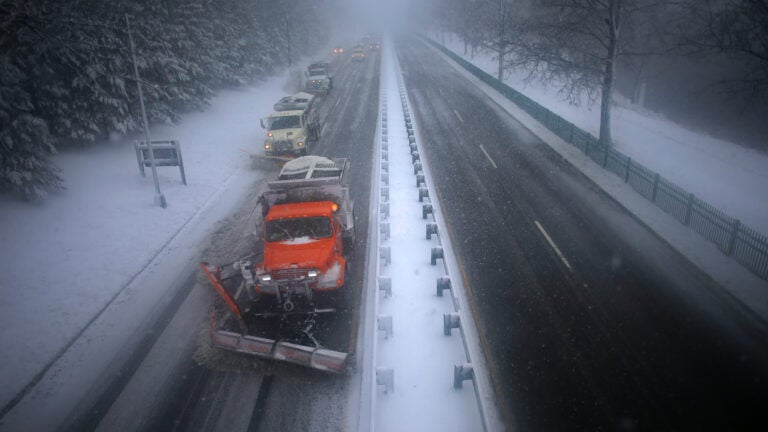
A winter storm set to bring snow, sleet, freezing rain, and rain is predicted to move through the Boston area Tuesday afternoon into Wednesday morning, according to local forecasters.
One of the main factors is timing, with the heaviest snow expected to fall during the evening commute.
Here’s the latest from local meteorologists on when to expect the worst of the storm and what it will be like:
David Epstein calls the storm a “small weather event,” adding that it’s a “nuisance” because of when it’s expected to strike — the heaviest snow is predicted for 4 to 8 p.m.
3 to 5 hours of snow this afternoon/evening. Just heard a newscaster use the word “big” in association w/ this small weather event. The only reason this is even more than a nuisance is because of timing. Unless you’re in your car driving during it, no big deal. pic.twitter.com/Ph6W7ci8jU
— Dave Epstein (@growingwisdom) February 12, 2019
By noon precip/snow will be falling across extreme southwest New England. Gets to eastern MA 2-4 pm. pic.twitter.com/ZaOODbCibK
— Dave Epstein (@growingwisdom) February 12, 2019
Snow arrives this afternoon and is heaviest during the 4-8 p.m. time frame. Mixing line moving north into Boston around 9-10 p.m. pic.twitter.com/p5GppwceDD
— Dave Epstein (@growingwisdom) February 12, 2019
3-6 inches of snow for the most populated areas of Massachusetts. More north and less south. Remember ultimately bands can end up slightly 10-15 miles further south or north. pic.twitter.com/sm5rjcOuFe
— Dave Epstein (@growingwisdom) February 12, 2019
WBZ’s Eric Fisher says there will be “pouring sleet” Tuesday evening. He called it “Just gross.”
Pouring sleet this eve after our initial snow burst. Just gross. pic.twitter.com/wwfY1CZEFN
— Eric Fisher (@ericfisher) February 12, 2019
No big changes tonight. Nasty roads…areas of heavy snow 3-7p, then switching to sleet. #wbz pic.twitter.com/eB1vhY00x0
— Eric Fisher (@ericfisher) February 12, 2019
HREF keeping the same idea we’ve been chatting about for tomorrow. Dumps snow for a couple hours, then we’re mostly sleet by 7pm. Heaviest snow band likely in the 4-6pm time frame so the commute will likely be a mess. #wbz pic.twitter.com/UH3Oa0nNeh
— Eric Fisher (@ericfisher) February 12, 2019
Fisher says the best time to clean up should be around 10 p.m. in Boston.
Maybe around 10pm for the Boston area. All the snow will be done, let some sleet fall into it for a couple hours, then remove. Warming above 32F after that https://t.co/5hjS0BKwBJ
— Eric Fisher (@ericfisher) February 12, 2019
Cindy Fitzgibbon called the storm “a sloppy, slushy waterlogged mess” for Wednesday morning.
Snow going to come in hard 1-3pm and it will snow heavily thru the evening commute. 4-6″ for many of us before a change to sleet and rain. A sloppy, slushy waterlogged mess by tomorrow AM as the storm moves out #wcvb pic.twitter.com/2hqT0mWVau
— Cindy Fitzgibbon (@Met_CindyFitz) February 12, 2019
Good Tuesday morning! Cold dry start- but snow moves in this afternoon. Comes on hard 1-3pm with heavy snow having a high impact on the evening commute. Turn on #wcvb now for timeline and totals pic.twitter.com/EC6faOHVRx
— Cindy Fitzgibbon (@Met_CindyFitz) February 12, 2019
Michael Page says the snow will transition to sleet “around dinnertime.”
SNOW: still on track for a 1-3 PM arrival for the snow around Greater Boston. Snow is moderate to heavy now in Southwestern Connecticut, where travel conditions are already getting sloppy. Snow goes to sleet around dinnertime, and then over to rain tonight.
— Michael Page (@MichaelPageWx) February 12, 2019
Danielle Niles says that around 3 p.m. there will be “snow covered roads, reduced visibility.”
Leading edge of snow arrives to central MA 12-1PM #WBZ pic.twitter.com/vFlQkaLVrH
— Danielle Noyes (Niles) (@danielle_noyes) February 12, 2019
3PM snapshot…snow covered roads, reduced visibility #WBZ pic.twitter.com/1get1xlHqP
— Danielle Noyes (Niles) (@danielle_noyes) February 12, 2019
The transition to sleet/freezing rain then plain rain works northward slowly during the late evening #WBZ pic.twitter.com/FBTplG5iYw
— Danielle Noyes (Niles) (@danielle_noyes) February 12, 2019
Temp continues to slowly rise overnight – tomorrow AM waking up to leftover showers…still could be a few slick spots in Worcester county into western MA #WBZ pic.twitter.com/yYh4DWwztn
— Danielle Noyes (Niles) (@danielle_noyes) February 12, 2019
Harvey Leonard says, “It’s all in the timing.”
It’s all in the timing. Snow begins early to mid afternoon Tue, and becomes moderate to heavy during the evening commute….between 4 and 8pm, 1″ per hour snowfall rate is possible…later Tuesday Night, it will change to sleet and then rain #wcvb pic.twitter.com/7ME3GMq3oX
— Harvey Leonard (@HarveyWCVB) February 12, 2019
Winter Storm Warning for The Berkshires. Winter Storm Watch for The Boston Area. Winter Weather Advisory for CT, R.I. and SE MA. Snow begins in Worcester around noon-1pm and in Boston around 2pm #wcvb pic.twitter.com/sbjVNZqMSv
— Harvey Leonard (@HarveyWCVB) February 12, 2019
Estimated snowfall Tuesday afternoon into Tuesday Night, before changing to sleet and then rain. That will cause the snow that accumulates to become compacted. #wcvb pic.twitter.com/9M74je94ce
— Harvey Leonard (@HarveyWCVB) February 12, 2019
The National Weather Service warns to not “be surprised to see a lot of sleet out of this storm.”
Snow, sleet, freezing rain! It’s a pain to forecast, but what’s behind it? Very cold air in place above which we’ll see warmer air build in later today and overnight. Don’t be surprised to see a lot of sleet out of this storm. pic.twitter.com/M53XdwZ2b3
— NWS Boston (@NWSBoston) February 12, 2019
Rough timing for metro areas when snow will begin …
Hartford / Springfield …. @ noon
Worcester / Providence … @ 1 pm
Boston … @ 2 pmIf you have an errands, can get out of work early, etc., try to get home @ these times b/c it’ll get a lot worse right after.
— NWS Boston (@NWSBoston) February 12, 2019
Are you prepared for today’s winter weather? The afternoon into evening commute is going to be a mess. If you can, please stay off the roads. This will be a high-impact event w/ slowed commutes, long drive homes, slick roads as moderate to heavy snow / sleet impacts the area. pic.twitter.com/csIPkTT20n
— NWS Boston (@NWSBoston) February 12, 2019
Winter storm warnings & advisories posted. Significant impacts for today’s afternoon into evening commute. If you can, stay home, stay off the roads, today is going to be a mess as moderate to heavy snow / sleet of @ 1″/hr hits our area beginning @ noon. pic.twitter.com/pkF4h2Y1mQ
— NWS Boston (@NWSBoston) February 12, 2019
https://twitter.com/NWSBoston/status/1095279395143593984