
Winter Watch
❄️ Get winter weather alerts and snow maps, delivered to your inbox.
After our messy storm system Thursday, we’ll have a bit of a lull before the next one arrives for the second half of the weekend. Let me just say at the outset that we are in a very active weather pattern and it’s likely that by the time things start to slow down, many of us will have received a foot or more of snow between today’s storm and all of next week.
There are several storm systems on the way, so let’s get to the weekend one first.
Saturday is going to stay dry and cold with temperatures in the mid-30s. This will be a good chance to check the snowblower, get a new shovel if you need one in advance of a big snowmaker approaching in the late evening. Saturday will also be a good time to get your errands done for those of you who had planned to go out shopping Sunday morning, but don’t want to do so in the snow. I do expect it’ll be a little more crowded at the supermarkets, especially with Super Bowl food shopping thrown into the mix.
This is not, however, the type of storm where you’re not going to be able to get out Sunday afternoon. So if you don’t want to deal with the crowds, just hold off until Sunday. The roads will be drivable pretty quickly in the afternoon and you will have all the parking space to yourself.
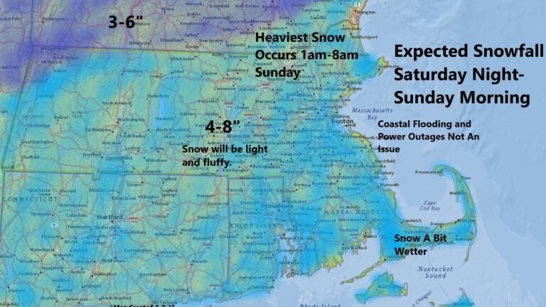
It’s still early, but I’m thinking many areas are going to get near and perhaps exceed 6 inches of snow with this upcoming storm. There should be less over Cape Cod and the islands and perhaps a little more to the north since it will be colder and the snow will be a little fluffier. This is a three-day estimate, so be prepared for changes to the snow totals in the coming days.
The bulk of the snow Sunday will fall between roughly 1 a.m. and 1 p.m. before tapering off.
This won’t be a particularly windy storm and the snow won’t be particularly wet, so I don’t think power outages are going to be much of a concern. However, anytime you get some snow piling up over 6 inches there is the chance for some scattered outages. Coastal flooding also will not be a factor during Sunday’s event.
The National Weather Service has issued a winter storm watch for Boston and the rest of Southern New England that’s in effect from 7 p.m., Saturday through 4 p.m., Sunday.
There are likely going to be some delays and cancellations at Logan Airport Sunday morning because the heavier snow is forecast around that time. Stay tuned for more details to come.
We will see a break in the action Monday and Tuesday before another storm threatens New England for the middle of next week with either more snow or a mixed bag of precipitation.
Southern New England: Look for sunny skies with temperatures in the 30s on Saturday followed by snow, especially the first half of Sunday with readings in the 20s to lower 30s. Some of the snow could be heavy.
Western Mass.: Sunshine is followed by a few high clouds by the end of Saturday and temperatures will be in the upper 20s. Look for snow Sunday, coming to an end in the afternoon.
Cape and Islands: Sunshine on Saturday features temperatures in the mid-30s. Look for snow perhaps changing to rain before coming to an end on Sunday afternoon. High temperatures will be in the 30s before falling back into the 20s.
Northern New England: Cold and dry weather on Saturday features temperatures around 30. Snow arrives early Sunday and continues throughout the day, heavy at times. Temperatures will be in the 20s.
❄️ Get winter weather alerts and snow maps, delivered to your inbox.


To comment, please create a screen name in your profile
To comment, please verify your email address
Conversation
This discussion has ended. Please join elsewhere on Boston.com