Tornado watch issued for Boston, most of Mass. and New England
A sector of warm and humid air will be hanging over much of Southern New England into the afternoon and evening hours, setting the stage for some potentially severe weather that could be produce heavy thunderstorms accompanied by strong gusty winds, hail and even an isolated tornado.
A tornado watch has been issued through 8 p.m. for Boston and all of Massachusetts, except for parts of southeastern Mass. and the Cape. The watch also covers northern Rhode Island, New Hampshire, Vermont, parts of Connecticut and southern Maine. A tornado watch for such a large area of New England is fairly unusual, although not unprecedented.
A tornado watch means weather conditions are favorable for thunderstorms capable of producing tornadoes. It does not mean that a tornado will occur, but it is best to be prepared. When a warning is issued, you should seek shelter right away by heading to the lowest level of your home or building where you are, such as a basement. If there is no basement, go to the center of a small interior room on the lowest level — closet, interior hallway — away from corners, windows, doors, and outside walls.
Upper-level energy will cross the region this afternoon and evening. This energy will help to lift the atmosphere and that is why showers and thunderstorms are likely to develop in the afternoon and evening hours.
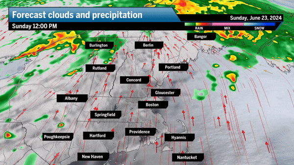
The greatest instability is going to be west of Interstate 495 and across western sections of Northern New England. It is these areas where severe weather is most likely.
Severe weather is much less likely east of I-495 and not likely throughout Greater Boston. Nevertheless, there still could be showers and thunderstorms with some gusty winds this afternoon and evening. The greatest threat comes between 5 p.m. and 9 p.m. in the Boston area, and earlier, before 5 p.m., north and west of Boston.
One of the ways in which meteorologists measure the amount of energy in the atmosphere available for severe storms is using something called the CAPE — which stands for “convective available potential energy.” The map above shows the location of the greatest CAPE this afternoon or instability of the atmosphere and provides an approximate idea of how much lift is within a thunderstorm.
Notice that the stronger forecast storm energy is west and north of the coastline. This is why I’m less concerned about severe weather in Greater Boston.
In terms of rainfall potential, anytime you get this type of pattern, there can be heavy downpours that can provide over an inch of rain in a short amount of time, but in general most areas are going to stay under half an inch of rainfall.
Once the threat of severe weather diminishes this evening, it will remain warm and humid overnight before drier air arrives on Monday. Tomorrow you will notice the dew points dropping throughout the day and the chance of showers is minimal, if at all, along with mostly sunny skies. Warm weather continues into Tuesday and Wednesday with an additional chance of midweek showers and thunderstorms.
Daily Local Weather Forecast
-
Today April 03Showers63° 53°
-
Sat April 04Mostly cloudy59° 37°
-
Sun April 05Rain62° 39°
-
Mon April 06Mostly cloudy50° 36°
-
Tue April 07Mostly cloudy48° 32°
-
Wed April 08Mostly sunny42° 37°
-
Thu April 09Partly sunny61° 46°
powered by:
Daily Local Weather Forecast
Hourly Forecast
- 40° Precipitation 43% 9AM
- 42° Precipitation 43% 10AM
- 44° Precipitation 40% 11AM
- 47° Precipitation 36% 12PM
- 51° Precipitation 29% 1PM
- 55° Precipitation 20% 2PM
- 58° Precipitation 20% 3PM
- 61° Precipitation 20% 4PM
- 63° Precipitation 20% 5PM
- 64° Precipitation 20% 6PM
- 62° Precipitation 13% 7PM
- 60° Precipitation 0% 8PM
powered by:


To comment, please create a screen name in your profile
To comment, please verify your email address
Conversation
This discussion has ended. Please join elsewhere on Boston.com