Spring storm packing snow, wind and rain hits New England
It’s “a typical early spring storm” with heavy mountain snowfall, a mix in the middle and rain for Massachusetts, Rhode Island.
Some light rain fell across Southern New England early Saturday, with elevated areas north and west seeing pockets of mixed precipitation. Snow and sleet were also accumulating across the border towns to the north.
In these areas, expect slower travel for a few hours this morning. Elsewhere, roads are wet, but wintry weather is not a significant part of our forecast for the Boston area. More on that below.

Looking closely at the radar loop from Saturday morning, you can see that the heaviest precipitation is still to the south. Our forecast has the bulk of the precipitation arriving after 4 p.m. and ending by about 9 p.m.

It is in that five-hour window that if you are traveling, you can expect some street flooding in poorly drained areas and some minor flooding of small streams and even rivers.
The key word here is “minor” and I always like to remind folks that flood warnings are issued whether the flooding is minor, moderate or major. One has to look at the details to know which type of flooding, and in the case of this storm, any flooding would be minor.
Rainfall totals should generally be 2 to 3 inches — another one of these heavier precipitation events. Fortunately, the ground isn’t frozen, so much of it will get absorbed in spite of the fact we’ve had adequate rain for many months.
Until the leaves come out, however, the ground remains quite saturated. Once the foliage emerges, the leaves tend to transpire more water and the trees and shrubs need more of it.

There won’t be a lot of wind with the system but there is one exception. As low pressure passes into the Gulf of Maine Saturday evening, a swath of stronger wind will cut across southeastern Massachusetts with higher wind gusts. As a result, there’s a wind advisory in these locations.
Below is a loop of wind gusts. Notice that little patch of stronger gusts crossing the Cape and the Islands. Some models tend to overdo the wind gusts, but certainly, some could reach 40 to 50 miles per hour for a short amount of time.

Winter weather alerts that have been issued:

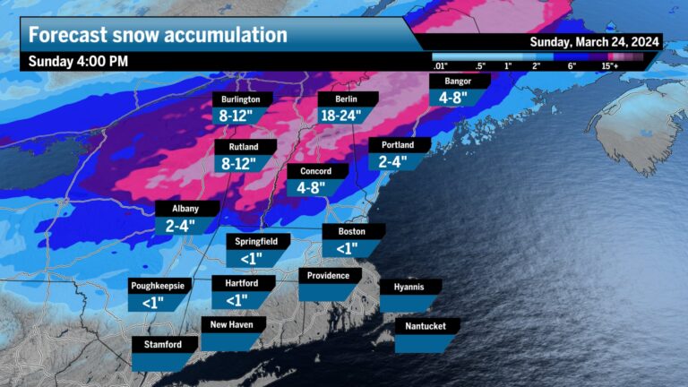
Across Northern New England this early spring storm is providing winter gold for ski areas. It’s been a snowy month for much of Vermont, New Hampshire and Maine and this storm is going to add to those totals. Mount Mansfield in Vermont has a longer-term database of snow depth, and you can see that even before this storm, the snow depth was above average for the time of year.

Some ski areas could receive upwards of 18 inches of snow at the peaks. The lower elevations will see anywhere from just a couple of inches along the coast in southern Maine to 4 to 8 inches into the foothills and then over 8 inches in those higher elevations. The amount of snow will vary quite a bit with height, and one of the maps I’ve been looking at this winter is the positive snow depth change forecast.
The map below is from the European model and shows how much snow is forecast to be on the ground after the storm. This is an excellent map to use in conjunction with the other ones to predict snowfall total, bu, it shouldn’t be taken literal like all computer guidancely.

On Sunday, it becomes somewhat blustery and still chilly but with sunshine. Temperatures are going to remain in the 40s, and I don’t see any significant change to the pattern until midweek, when readings should get back into the 50s. There could be a few more showers in the final days of the month, a prelude to those April ones.


To comment, please create a screen name in your profile
To comment, please verify your email address
Conversation
This discussion has ended. Please join elsewhere on Boston.com