Newsletter Signup
Stay up to date on all the latest news from Boston.com
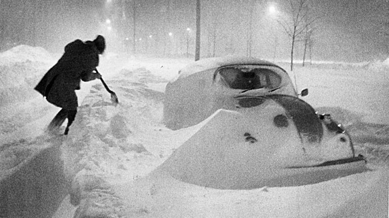
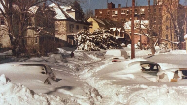
Forty-five years ago today, Massachusetts was feeling the fury of the Blizzard of ’78 — a 27.1-inch blanket of snow that buried the commonwealth over two days. With snow falling at a rate of 4 inches per hour, the Bay State suffered what was, at the time, the worst snowstorm recorded in its history.
Weather computer models were still relatively new, but many accurately predicted the severity of the storm as it approached on Feb. 5, 1978. However, due to skepticism from busted forecasts days before, many still commuted to work, leaving their homes with little concern that more than two feet of snow would actually fall within 48 hours.
But that morning’s forecasts were right: hurricane-like winds, abandoned cars scattered across icy roads, storm surges and waves that destroyed houses, and over 25 inches of snow brought Massachusetts to a halt.
So, what’s to keep that scenario from repeating itself today?
Through a combination of more accurate data collection, precise weather models, and accessible forecast predictions, meteorologists’ ability to accurately predict a snow storm of this magnitude has risen steadily over the past 45 years, say weather experts.
Along with expanded communication and response procedures, it is increasingly unlikely that something like the Blizzard of ’78 would catch us by surprise today, they say.
While it is possible that Massachusetts could see similar levels of snowfall — The President’s Day Blizzard of 2003 recorded 27.6 inches of powder at Logan Airport — meteorologists’ increased ability to collect accurate storm-indicating data has “been a game changer,” Judah Cohen, visiting scientist at MIT’s Department of Civil and Environmental Engineering and Director of Seasonal Forecasting at Atmospheric and Environmental Research, told Boston.com.
“The satellites, the ships, the weather stations, weather balloons used to integrate and assimilate all that data are much better than they used to be,” Cohen said.
And once that data is collected, the models the meteorologists use and the methods used to create them have also improved since the ’70s.
Meteorologists use models called Numerical Weather Predictions, or NWP’s, that plug observed weather information into numerical algorithms to make location- and time-based weather predictions. In 1978, only one model from the National Weather Service was used for forecasting predictions. Today, over 50 models are aggregated from several organizations, mitigating error and increasing accessibility.
“The models that are run are much better, obviously much stronger. Computers are much faster, processing the data much more accurately,” Cohen said. “You don’t have to be a Ph.D. in meteorology to know when there will be a snow storm. Back then, in ’78 … the data was only found within the weather service … We knew how to read the data and make make sense of it. But now it’s much more widely available.”
Today, these models are also able to predict accurate storms days to weeks in advance, and with easily understandable maps and graphics, the public’s ability to understand incoming weather has increased greatly. (And, presumably, so has its penchant for taking those forecasts seriously, unlike the skeptical commuters of 1978.)
Just as important as predicting snowstorms is the joint effort needed to respond to one. Coordination and communication between meteorologists, federal and state weather services, and emergency response teams is crucial to responding to something like a blizzard of ’78, Glenn Field, warning coordination meteorologist at the National Weather Service, told Boston.com.
“We now have a really … much more organized and established network of communication with all of our emergency management partners,” Field said.
Through emails, conference calls, and PowerPoints, coordination and internal communication between federal and local agencies starts days in advance of potential storms. Meteorologists are also more willing to share data and forecasting techniques, making forecasts more accurate and accessible to the public, according to Field.
“There’s just much better communication,” he said. “When mother nature throws us a curveball … everybody gets on the same page pretty quickly.”
But the innovation that has likely spurred greatest increase in blizzard preparedness is pretty simple: the use of cell phones.
According to the Massachusetts Emergency Management Agency, or MEMA, one of the most impactful changes to weather emergencies is the widespread use of cell phones and social media.
Whether it be on Twitter, Facebook, or Instagram, organizations like MEMA can post alerts and messaging regarding upcoming weather emergencies. Additionally, they can send weather emergency alerts directly to cell phones based on their specific location — providing people with timely and trusted information.
“Of course one of the biggest changes is Twitter, Facebook, and other social media,” Field said. “That’s a big part — getting the word out on [social media] multiple times a day.”
Stay up to date on all the latest news from Boston.com


To comment, please create a screen name in your profile
To comment, please verify your email address
Conversation
This discussion has ended. Please join elsewhere on Boston.com