City abuzz with Obama visit, World Series game; street closures, parking restrictions planned
With President Obama visiting the city this afternoon and Game 6 of the World Series slated for tonight, there’s plenty of excitement in Boston — and plenty of chances to get tangled up in traffic.
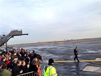
Obama landed at 2:46 p.m. at Logan International Airport. He will speak about the Affordable Care Act at Faneuil Hall around 4 p.m., according to a statement from the White House.
This evening, the Red Sox will face off with the Cardinals in the potentially clinching World Series game.
Fans have been asked to use public transportation by the city of Boston. Mayor Thomas M. Menino on Tuesday encouraged businesses to tell employees to leave an hour early, preferably by 4 p.m.
The Massachusetts Department of Transportation said the high-occupancy-vehicle lane on Interstate 93 South opened early at 2 p.m. today to accommodate heavy traffic from people leaving the city to avoid the hubbub.
Streets will be closed temporarily to allow passage of Obama’s motorcade. After the Faneuil Hall event, he is expected to attend a fund-raising event in Weston.
At the same time, thousands of officers will be stationed in and around Fenway Park for the game. After the 6th inning, State Police will be closing Kenmore exits from both sides of Storrow Drive, the Bowker Overpass, Charlesgate east and west, and the Landmark Center intersection.
After the 7th inning, no pedestrians or vehicles will be allowed near Fenway. The MBTA will stay open to accommodate Sox fans until the ballpark is cleared, according to the MBTA.
Some areas of the city will restrict parking after 4 p.m. today, including some streets in Brighton, the Kenmore Square/Fenway area, and Fanueil Hall, among others. The parking ban will remain in place until 2 a.m. Thursday, and includes vehicles with Boston parking permits.
The full list of streets with parking restrictions:
BRIGHTON AREA
Beacon Street
Both sides, from Chestnut Hill Avenue to Ayr Road
Brighton Avenue
Both sides, from Chester Street to Allston Street
Cleveland Circle
Cassidy Playground Area – Both sides of Metered Area
Sutherland Road Area – Both sides of Metered Area
Harvard Avenue
Both sides, from Commonwealth Avenue to Cambridge Street
KENMORE SQUARE/FENWAY AREA
Bay State Road*Both sides, from Beacon St. to Granby Street.
Beacon Street
Both sides, form Kenmore Square to Park Drive
Boylston Street
Both sides, from Mass. Ave, to Park Drive (Brookline Ave./Boylston St.)
Brookline Avenue
Both sides, from Beacon Street (Kenmore Square) to Park Drive
Burlington Street
Both sides, from Brookline Avenue to the Dead End
Commonwealth Avenue
Both sides, both roadways, from Massachusetts Avenue to the Boston University Bridge
Deerfield Street
Both sides, from Commonwealth Avenue to Bay State Road
Ipswich Street
Both sides, from Boylston St. (Hemenway) to Boylston Street (Sunoco Gas Station)
Jersey Street
Both sides from Boylston Street to Peterborough Street
Kenmore Square (in its entirety)
Both sides, both roadways, from Kenmore/Raleigh Streets to Deerfield Street/Beacon Streets
Kilmarnock Street
Both sides, from Van Ness Street to Peterborough Street
Lansdowne Street
Both sides, from Brookline Avenue to Boylston Street
Newbury St. Extension
Both sides form Beacon St. to Charles Gate West
Park Drive (DCR Roadway)
Left side, Left roadway (Roberto Clemente Park side) from Aggassi Road to opposite Kilmarnock Street
Raleigh Street
Both sides from Bay State Road to Commonwealth Avenue
Van Ness Street
Both sides, from Ipswich Street to Kilmarnock Street
Yawkey Way
Both sides, from Boylston Street to Brookline Avenue
Fullerton Street
Both sides, from Brookline Avenue to the Dead End
Overland Street
Both sides, from Brookline Avenue to the Dead End
Peterborough Street (in its entirety)
Both sides, from Park Drive to Park Drive
NORTHEASTERN AREA
Gainsborough Street
Both sides, from Huntington Avenue to Hemenway Street
Hemenway Street
Both sides, from Forsyth Way to Boylston Street
Symphony Road
Both sides, from Saint Stephens Street to Hemenway Street
Saint Stephens Street
Both sides, from Westland Avenue to Forsyth Way
Opera Place
Both sides, from Saint Stephens Street to Huntington Avenue
Westland Avenue
Both sides, From Hemenway Street to Massachusetts Avenue
Forsyth Street
Both sides, From Hemenway Street to Huntington Avenue
Forsyth Way
Both sides, From Huntington Avenue to the Fenway
FANEUIL HALL AREA
Blackstone Street
Both sides, from Hanover Street to North Street
Congress Street
Both sides, from Nw Chardon Street to State Street
North Street
Both sides, from Surface Road to Congress Street
Union Street
Both sides, from North Street to Hanover Street
Clinton Street
Both sides, from North Street to Surface Road
State Street
Both sides, from Surface Road to Washington Street
Hanover Street
Both sides, from Congress Street to Surface Road
NORTH STATION AREA
Causeway Street
Both sides, from Merrimac Street to North Washington Street
Canal Street
Both sides, from New Chardon Street to Causeway Street
Friend Street
Both sides, from New Chardon Street to Causeway Street
Portland Street
Both sides, from New Chardon Street to Causeway Street
Lancaster Street
Both sides, from Merrimac Street to Causeway Street
Merrimac Street
Both sides, from New Chardon Street to Causeway Street
Beverly Street
Both sides, from Causeway Street to North Washington Street
Haverhill Street
Both sides, from Rip Valenti Way to Causeway Street
Rip Valenti Way
Both sides, from Merrimac Street to North Washington Street


To comment, please create a screen name in your profile
To comment, please verify your email address
Conversation
This discussion has ended. Please join elsewhere on Boston.com