Traverse Franklin County bridges, farm country, and forest on this trail
We can’t say for sure that Franklin County has its equivalents of lonely farm wife Meryl Streep and lone-wolf photographer Clint Eastwood, stars of the 1995 movie “The Bridges of Madison County.’’ But the hill country sandwiched between the Connecticut River and the Berkshires sure has its share of fine wooden covered bridges. Its inhabitants have been building — and rebuilding — covered bridges since the early days of the nation.
Franklin County’s five remaining spans form a nice cluster that links up in a drive of slightly more than 53 miles on back roads. The trail follows the course of the streams and brooks that run around the hills, leading through some of the state’s most picturesque farm country and forest. Outdated, often prematurely elegiacal information about these bridges abounds on the Internet, as several spans have been rebuilt or substantially repaired in recent years.
Adams Donuts on the north side of Greenfield is the best place to start. The shop opened in 1956 and continues to hold its own despite the presence of nearby Dunkin’. The de rigeur selection for a covered bridge road trip is the glazed blueberry cake doughnut, arguably the apotheosis of its ilk. Once you turn off Route 5 north, the journey twists through a mixture of narrow woods and open land where chickens, ducks, and geese strut about the farmhouse dooryards.
Crossing the Green River on Eunice Williams Road, the first of the covered bridges is known in Greenfield town records as the Pumping Station Bridge. Bridge lovers tend to call it the Eunice Williams Bridge. The lady in question was slain at the site on March 1, 1704, as part of the Deerfield Massacre. Her husband, the Rev. John Williams, observed the death by hatchet and was himself marched off by the Mohawks to captivity in Quebec. On his return two years later, he recounted the bloody details in his memoir, “The Redeemed Captive.’’
It’s a tranquil spot for a river crossing with such a dark history. The original covered bridge was constructed in the 19th century and stood for about a century before it was burned by vandals on Halloween 1969. A bronze plaque lists the 66-member workforce that rebuilt the 95-foot bridge, which reopened in 1972. Knocked off its base by tropical storm Irene in 2011, the bridge was repaired again and reopened in 2014. It crosses the Green River just downstream from the pumping station and falls. Don’t be surprised to see trout fishermen along the banks.
The trail continues through the single-lane bridge, winding through the hilly woods en route to Colrain. You might be able to buy fresh eggs from roadside tables with hand-lettered signs. You can definitely load up on local provender — apples, beer, hard cider, honey, bee pollen, and seasonal vegetables — at Pine Hill Orchards. The market’s deli/restaurant has soups, sandwiches, and salads. Many people stop in to visit the pet rabbit, Mac, who hops blithely around the store.
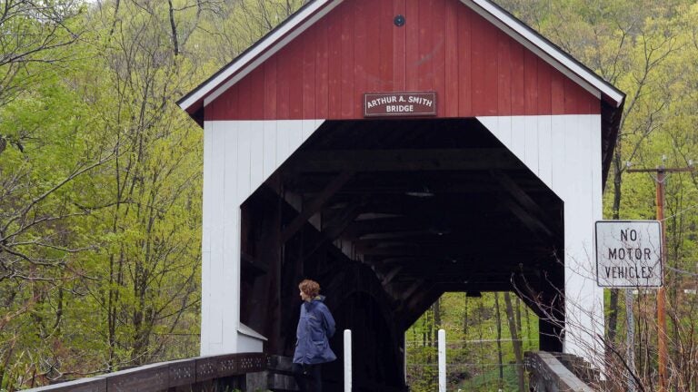
Back on the road, the route passes through the blink-and-you’ll-miss-it village center of Colrain as it turns left on Route 112 toward Shelburne Falls. The Arthur A. Smith Covered Bridge, the only one of the five bridges that bans motor traffic, squats a mile south of Colrain village on Lyonsville Road over the North River. The handsome red and white 99-foot span depends on a single great arch on each side for its strength. Built elsewhere around 1870 and moved to this spot in 1896, it was taken out of service in 1991 and allowed to decay in a cornfield. But the Colrain Historical Society rallied behind the landmark. The bridge was rebuilt and reset on its abutments in 2006.
Route 112 continues south through the bustling village of Shelburne Falls, with multiple temptations for shopping or eating. After crossing the “iron bridge’’ (just downriver from the Bridge of Flowers tourist attraction), make a sharp left to follow along the Deerfield River and eventually connect to Route 116 north toward Conway. The Burkeville Covered Bridge (sometimes also called the Conway Covered Bridge) sits just west of the village center. It carries Main Poland Road over the South River.
Some bridge fans claim this is the oldest surviving covered bridge in the country, but it’s hard to substantiate the claim. Even the signage can’t agree. It was either built “about 1869’’ or in 1870 to replace an earlier bridge washed away in a storm. Closed in 1985 for safety reasons, the bridge was rebuilt in the early 21st century and finally reopened to vehicular traffic in 2013.
The 106-foot-long bridge is a great early example of the Howe truss. Invented and patented by William Howe of Spencer in 1840 and improved in 1850, the Howe truss combines criss-cross diagonal timbers with vertical iron tensioning rods. The resulting lattice stays level over very long spans. Howe’s truss design quickly became the gold standard for long, one-span covered bridges in New England.
The road climbs and winds in the hilly terrain, following along the banks of the South River as it ascends toward the village of Ashfield. Just outside the village, Creamery Road diverges to follow along a small brook. Creamery Bridge crosses that brook at 869 Creamery Road. Look for the sign on the left for the Creamery Bridge Sugar House. Built in 1985 by the Scott family to provide access to their property, the bridge is essentially a small rectangular barn open on both ends. Inside the bridge, the Scotts sell their maple syrup and maple vinegar on the honor system.
At the end of Creamery Road, a right turn onto Route 112 leads northward through Buckland village to join the Mohawk Trail (Route 2) just west of Shelburne Falls. The drive passes through hillside hay meadows and orchard country before it follows the rippling shallows and heron-haunted back eddies of the Deerfield River en route to Charlemont.
The final covered bridge of Franklin County, the Bissell Bridge on Heath Road (Route 8A) in Charlemont, embodies the enduring appeal of these wooden passageways over treacherous waters. When the state condemned the 19th century wooden bridge over Mill Brook , Charlemont folk fought replacing it with an iron bridge. Instead, it was rebuilt in 1951 using a modernized version of the original design so it could safely carry two lanes of cars and trucks. As wooden bridges do, it also decayed in the weather and was closed in 1995 — only to be reconstructed and reopened in 2009. There are few safe places to park along the roadside, so you might have to hike uphill to the little observation deck to watch the brook tumble tumultuously beneath the bridge and down the steep hill to town.
Should you find yourself at the end of the day wondering about a meal, the Cold River Café, just around the corner on Main Street, serves a full menu, including house barbecue and pizza.
If you go . . .
A Google Map delineates the route: goo.gl/maps/YvGbSw7BYdx
Adams Donuts, 348 Federal St., Greenfield, adamsdonuts.com, 413-774-4214. Open Mon-Sat 5 a.m.-noon.
Pine Hill Orchards, 248 Greenfield Road, Colrain, www.pinehillorchards.com, 413-624-3325. Deli open Mon-Fri 6 a.m.-4 p.m., Sat-Sun 7 a.m.-4 p.m.
Cold River Café, Market & Package, 31 Main St., Charlemont, coldriverpackage.com, 413-339-0000. Cafe and restaurant Sun-Thu 6 a.m.-8 p.m., Fri-Sat 6 a.m.-9 p.m.