From Slaughterhouse to Romantic Suburb: Aberdeen Architectural Conservation District
The Aberdeen district in Brighton was once one of the cattle capitals of New England.
This is the eighth in a nine-part series on Boston.com about historic districts in the city of Boston.
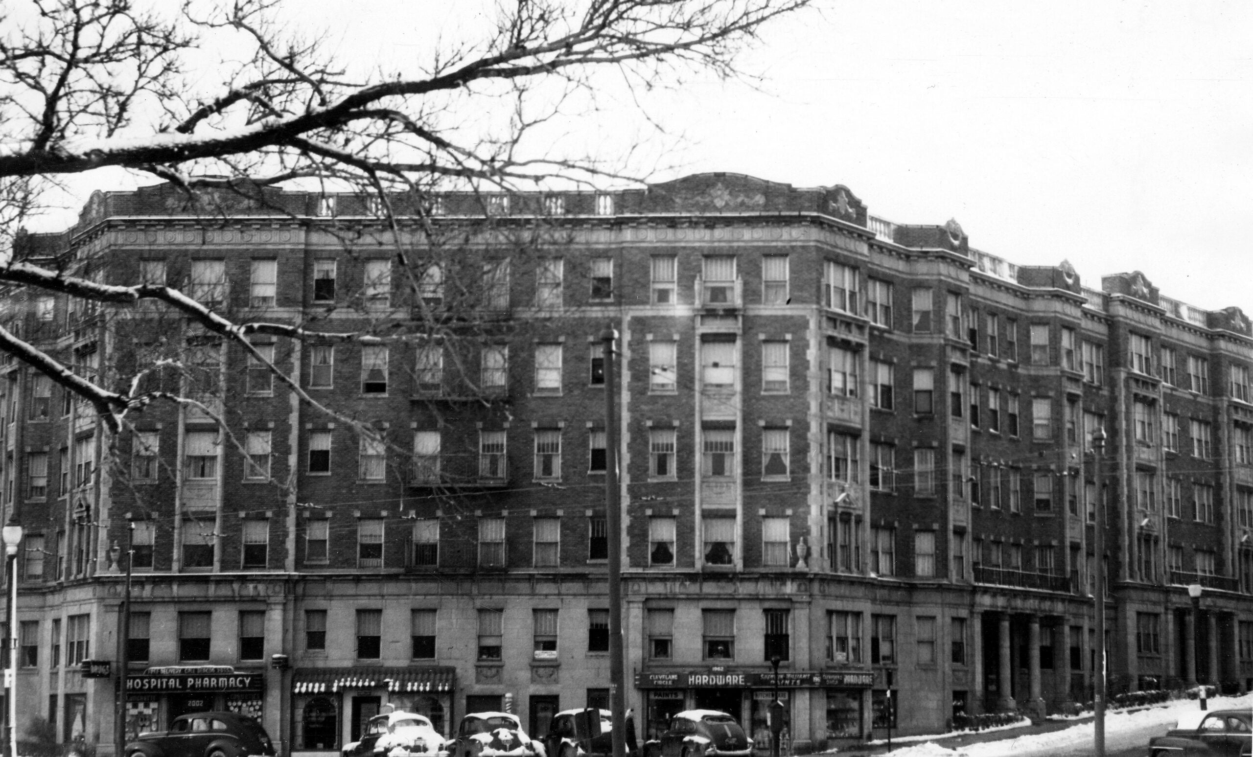
When driving down Commonwealth Avenue between Washington Street and Greycliff Road in Brighton, it might be easy to fixate on the huge apartment buildings and the Green line train running down the middle of the wide thoroughfare, but turn down one of the side streets and enter what was once considered a “romantic suburb’’ where city life seems a million miles away.
Brighton’s Aberdeen district is a small neighborhood that borders on Commonwealth Ave. and the Chestnut Hill Reservoir in Brighton, where the unique feel reflects the area’s streetcar suburb history.
[fragment number=0]
This Puritan settlement stretches back to at least the 1630s, when it was mainly used for grazing cattle, according to the Landmarks Commission Study Report on the Aberdeen Architectural Conservation District. During the Revolutionary War, the area supplied Continental Army troops stationed in Cambridge with beef.
The district stayed completely rural into the 19th century, according to the report. In fact, Washington Street, the oldest street in the district, was called “the great Country Road.’’
Brighton, which includes Aberdeen, was a part of Cambridge for some time and then in 1807 became its own city until it was officially annexed by Boston in 1874, according to the report.

Once the Boston and Worcester Railroad arrived in Brighton in 1834, the cattle farms and gardens in the area became tourist destinations, according to the Landmarks Commission. Population increased and some development started in the area. Beacon Street was laid out in 1850 and the Charles River Railroad (now the MBTA D Green line track) was created in 1867.
The Chestnut Hill Reservoir’s construction was completed in 1870 and became a large player in Boston’s water system, storing all of the Hub’s water in one location compared to the many there were before, the report said. Residential development began soon after.
According to the Allston-Brighton Historical Society, Historian S.F. Smith described the reservoir in 1880 as:
“The spot is a lovely one. There are cultivated hills around the basin from which fine views may be had of its winding and graceful lines, and its sparkling sheets of water…. The scenery is pleasantly diversified with glimpses of deep blue water, and groves of trees and plots of green grass.’’
Though the reservoir made the neighborhood more visually appealing, there was still a cattle presence in the area.
“This area was primarily agricultural and developed late compared to other suburban areas because of slaughterhouses,’’ said Erin Doherty, the preservation planner for the Aberdeen district. “And the landscape itself and rock outcropping inhibited housing.’’
Slaughterhouses and the terrain were both deterrents for people considering inhabiting the area.
Dr. William P. Marchione, an Allston-Brighton historian, wrote that the slaughterhouses, particularly the Curtis & Boynton Slaughterhouse near the intersections of Sutherland Avenue and Commonwealth Avenue, were described as:
“The largest [slaughtering] business in Brighton at the time of the Civil War [Curtis & Boynton] employed from thirty to fifty men and required a stable of about 25 work horses to do the trucking with frequent employment for hired teams. This business was that of slaughtering hogs, rendering lard, and manufacturing lard oil. The offal from the slaughterhouse was usually piled up out in the open air and quite often not covered with anything, and was thus allowed to decay.’’
The slaughterhouses closed in the 1870s and residential development began in the areas around Aberdeen within about a decade. The Mission Hill streetcar suburbs started development in the 1870s.
According to the Landmark Commission’s study, Henry M. Whitney, an executive at the Metropolitan Steamship company, did two things to kick-start construction in the district: start the West End Street Railway Company and ask Frederick Law Olmstead to widen Beacon Street.
Streetcars were electrified by 1889 and Commonwealth Avenue was completed to go as far as the Aberdeen district by 1892.

“Aberdeen is an early streetcar suburb and it also represents a period of growth related to the expansion of the street car service,’’ Doherty said. “There is a very diverse collection – single family homes and large apartment blocks.’’
According to the Landmarks Commission, the Aberdeen Land Company first built homes that were freestanding and developed as a “Romantic Suburb’’ along the natural twists and turns of the area’s landscape. Apartments started going up in 1909 and between 1910 and 1930 the population of Allston-Brighton doubled. The variety of housing built during that time is still visible today.
“One of the main thoroughfares is Commonwealth Ave., but as you make your way south of Comm. Ave. there are a series of streets laid out by Aberdeen — winding streets that are quite different from Comm. Ave.,’’ Doherty said. “On these back streets you have single family houses right next to large apartment blocks that a lot of people aren’t aware of. People don’t know they are in a historic district and don’t realize what are on these sides streets.’’
The Landmark Commission’s report recommended that Aberdeen be considered for historic district status due to its variety of housing styles and unique topography.
“Its unique character was recognized and its importance to the history of suburban development was appreciated,’’ Doherty said.
The Landmarks Commission designated the Brighton neighborhood as the Aberdeen Architectural Conservation District in 2001.
Architectural Styles
The large homes in this district were built in a variety of styles including Colonial Revival, Queen Anne, and Shingle, according to the report.
– Colonial Revival: Architects in different cities interpreted Colonial Revival, which was sparked by the 1876 centennial celebration of the founding of the United States, in a variety of ways. One of the main architects in the Aberdeen district, E. Little Rogers designed his house on Englewood Avenue in this style. It included “a highly symmetrical main facade dominated by a pedimented center pavilion, with a Tuscan-columned entrance porch projecting from the center of the Englewood Avenue elevation. Opening on to the roof of the front porch is a modified Palladian window.’’

– Queen Anne: According to the Landmark Commission, Queen Anne “represented a revival of early English baroque motifs and craft traditions prevalent in Britain as late as the reign of Queen Anne (1702-1714).’’ The Boston Preservation Alliance says this style is known for being irregular, having turrets and porches in unexpected places and abundant decorative details.
-Shingle Style: Showcasing the forms popular in Medieval English homes and First Period New England dwellings, this style has tower-like structures and roofs with broad gables.
Famous Sites in Aberdeen
– 89 Englewood Ave.: According to Doherty, this is the earliest surviving suburban house in the district, built in 1886. “It is a brick Queen Anne single family home and this relates to the early period of development,’’ Doherty said. “There were a number of brick residencies in the vicinity, but all have been demolished for apartment buildings.’’ (They were demolished before the district gained its special protected status.)
– 1642 Commonwealth Ave.: “It is a fairly large stone craftsmen house built in 1910,’’ Doherty said. “It was constructed as a single family home.’’
– 45 Lanark Rd.: “This is a fairly intact high-style shingle house and it retains its large lot and original features,’’ Doherty said.
Regulations
Doherty said that the Landmarks Commission guidelines for this district are unique in that they cover landscaping.
“Any significant alterations to landscape, like removal of stone outcroppings or trees – that is something that would be reviewed,’’ said Doherty. “There are specific guidelines that speak to landscape changes. That really speaks to how important those features are to the neighborhood.’’

Since Aberdeen was declared a district much later than others, the Commission is aware that changes may have been made to the original designs of the homes in the area.
The guidelines state: “Changes and additions to the property and its environment that have taken place in the course of time are evidence of the history of the property and the neighborhood. These changes to the property may have developed significance in their own right, and this significance should be recognized and respected. (The term ‘later contributing features’ shall be used to convey this concept.)’’
The guidelines then extensively cover how to maintain the building exteriors with the goal of preserving “the overall character and appearance of the buildings in the Aberdeen Architectural Conservation District, including their exterior form, mass, materials and richness of detail.’’
Any questions, concerns, or proposals for exterior change should be brought up with the Boston Landmarks Commission.


To comment, please create a screen name in your profile
To comment, please verify your email address
Conversation
This discussion has ended. Please join elsewhere on Boston.com