Fort Point redevelopment plan will turn Boston neighborhood into an open space oasis
As proposed, 88.7 acres largely occupied by office space and parking would become a blend of public space and private developments.
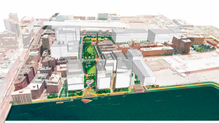
A waterfront Boston neighborhood could look and function quite differently a few years from now thanks to an ambitious master plan created by the Boston Planning and Development Agency (BPDA).
As proposed, 88.7 acres along Fort Point Channel largely occupied by office space and parking lots would turn into a blend of public space and new private developments, including two big parks, pocket parks, a promenade, and an amphitheater, among other outdoor and recreational amenities.
Currently, the project area — bounded by Fort Point Channel to the west, Summer Street to the north, South Boston Bypass Road/Haul Road to the east, and West First Street to the south — feels isolated from the rest of Boston, according to the BPDA.
The goal of the plan is to make the network of parks a destination for families, one that brings Bostonians from every neighborhood to the waterfront for a day full of activities, according to Rich McGuinness, the BPDA’s deputy director for climate change and environmental planning.
“How can we make sure that these new parks are attractive to families from all neighborhoods of Boston and are easily accessible, not just formal lawns or corporate landscapes that are just an accessory to water and nearby buildings?” McGuinness said. “How can we make this more signature open space?

What are the key features?
The plan begins with Fort Point Channel Park, a revamped waterfront park that features a heavy emphasis on design elements that float: Floating wetlands, a waterfront overlook, infrastructure to support a floating stage or visiting activity barges, and floating art are all listed in the plan. Also listed as focal points are elevated places to enjoy views of the channel and creative swings along the Harborwalk, which have already proved to be popular draws at South Boston’s Lawn on D
As you work your way south from the channel, a park promenade will connect each of the parks, and will also link up with the Harborwalk and South Bay Harbor Trail, building links to other neighborhoods for pedestrians. The four other parks listed are Necco Street Park, Wormwood Street Park, Active Park, and Medallion Street Park.
Among the many features listed for the new parks: an interactive fountain designed for children; an outdoor lounge area with seating and lawn games; picnic tables and grills; benches and seating, including a “Hammock Grove;” shade structures to provide relief from the heat; active recreation, including at least one regulation basketball court; interesting play areas; affordable food options; and complimentary indoor public facilities that support enhanced enjoyment and use of the parks.
The parks will also host art and performance events, with a planned waterfront amphitheater, public art throughout the district, and an “Art Promenande” in the planned elevated plaza.
Other highlights in an initial design include spaces for physical recreation (kayak launch, Tai-Chi/Zumba space, a fitness station, dog park, multi-use sports courts, and a skate park), and nature (pollinator, community, and rain gardens, as well as nature play).

Why?
The proposed goals of the interconnected parks are to strengthen connections to the waterfront and expand recreation, events, and green spaces for both neighborhood residents and visitors, according to the BPDA. The BPDA also hopes that the plan will help draw visitors, giving Bostonians whose neighborhoods don’t have waterfront access a reason to make the trip to Fort Point, which skews older, whiter, and wealthier than most of Boston.
According to Joe Christo, BPDA’s senior resilience and waterfront planner, the plan’s core values call for a network of parks that are resilient, welcoming, inclusive, and accessible. While designing the plan, committee members looked at other parks, like New York City’s Brooklyn Bridge Park, that inspire all-day visits.
“We pushed the boundaries of the parks to make them bigger in order to give them a destination quality,” Christo said. “If you want to stay for the day, what sort of amenities do we have? What are the physical aspects of the park and the design that allow for that?”
What about climate change?

A key consideration when reimagining the Fort Point neighborhood is the prospect of rising sea levels. Because the area is currently “largely flat, gray parking lots,” as Christo put it, there was a lot of room to start from scratch.
The berm will be raised 14 inches from its current level, with gradual sloping created to mitigate flooding or spillover into other neighborhoods.
Additionally, the parks themselves will protect against rising temperatures. Currently, the large parking lots contribute to an “urban heat island effect,” which intensifies the impacts of hot weather. By adding hundreds of trees and shade areas, the parks will increase the Fort Point canopy and lead to a cooling of the neighborhood.
The design team used baseline recommendations from the city’s climate action plan as well as coastal resilience solutions for South Boston provided by Climate Ready Boston.
We have industry-leading modeling in that report that looks at sea level rise and increased coastal storms through 2070,” Christo said. “We had a really great starting point and then went one step further beyond what those coastal resilience solutions were proposing.”
What’s next:
The plan is to build the parks in two phases, starting with Necco Street Park and Fort Point Channel Park Phase 1 and continuing with the parks farther from the water in Phase 2. Because the design plan is contingent on the private developments being built in the area — including ones at 15 Necco St. and 244 A St. — an exact timeline for the construction of the parks has not yet been established.
McGuinness said that once 15 Necco St. receives permitting from the state to begin construction, which is currently under consideration, his best estimate was that construction would take two years. The 244 A St. development is slightly behind 15 Necco in the permitting process, but once the requisite permits are secured, it would probably face a two-year build as well, he said.
In the meantime, the BPDA suggests that the city begin holding “short-term activations” in the area to make residents aware of the space even before construction begins.
“Temporary programming could begin sooner (as allowed with current COVID public health guidelines), beginning the process of making these spaces better known throughout the city and providing events for the local neighborhood,” the plan reads. “For example, the existing parking lots could host events, markets, or festivals, foreshadowing the types of activities that will be available when the new parks fully open.”
Check out more images from the BPDA’s plan below, or visit the BPDA website to view the full planning document.
Subscribe to the Globe’s free real estate newsletter — our weekly digest on buying, selling, and design — at pages.email.bostonglobe.com/AddressSignUp. Follow us on Facebook, Instagram, and Twitter @globehomes.


To comment, please create a screen name in your profile
To comment, please verify your email address
Conversation
This discussion has ended. Please join elsewhere on Boston.com