Hurricane Lorenzo packs Category 4 winds – and presents an ominous climate signal
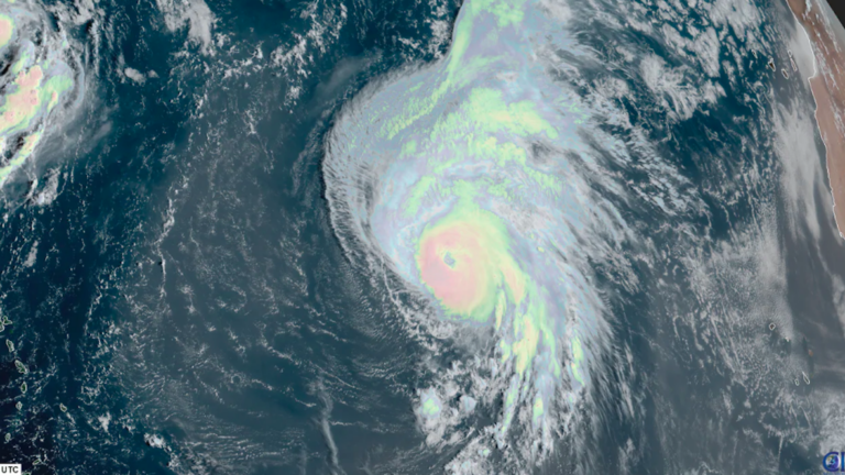
Its cloud shield would be enough to cover the entire East Coast beneath overcast.
As Tropical Storm Karen withers away, Hurricane Lorenzo has become “one of the largest and most powerful hurricanes of record for the tropical central Atlantic,” according to the National Hurricane Center.
Now packing 140 mph winds, Lorenzo became a Category 4 storm Thursday farther east than any other previous storm on record – save for Julia in 2010. While far from any populous land masses at the moment, Lorenzo may come to impact the Azores in just under a week’s time – all the while marking a potentially ominous climate signal.
The Category 4’s sprawling cloud shield spans more than 1,000 miles – roughly the distance from Washington D.C. to Miami; including its outflow, it would be large enough to cover the entire East Coast beneath overcast.

Hurricane Lorenzo’s eye has become a bit more poorly defined in the most recent satellite imagery, but it’s expected that Lorenzo will remain a major hurricane through the weekend.
Lorenzo had the makes of a top-tier storm from the start. The National Hurricane Center delineated it as an area to watch with a “likely” chance of development even while a mere tropical wave over the African continent.
Lorenzo quickly bloomed immediately after exiting the African coast into the tropical Atlantic Ocean, becoming a tropical storm around lunchtime Monday. Its rate of strengthening has been notable.
At 5 a.m. Wednesday, Lorenzo was declared the fifth Atlantic hurricane of the 2019 season. A day later, the National Hurricane Center announced Lorenzo has “rapidly [strengthened] into a major hurricane.” By Thursday mid-morning, Lorenzo was a Category 4, its winds having jumped from 85 mph to 130 mph in just 24 hours.
Zooming out— here’s a look at how large #Lorenzo is. About 700 miles wide in the cloud shield, with TS winds in 300-400 miles of that. There’s no hurricane on record that strong and large there- looks more like a WPac super typhoon pic.twitter.com/p9zOk7n1Ks
— Eric Blake 🌀 (@EricBlake12) September 26, 2019
Lorenzo is enormous. Its hurricane-force winds extend up to 45 miles from the center, with tropical storm force winds reaching out 265 miles.
Passing over somewhat cooler water, the storm is beginning to slowly weaken. Recent satellite scans have revealed warning cloud tops, indicating slightly less vigorous updrafts within the storm’s core.
Meanwhile, the eye has lost the crisp, symmetric character it had maintained Thursday. Microwave satellite imagery also suggests the inner eyewall has weakened some.
Lorenzo is expected to maintain strength or gradually decline in peak winds over the coming days but will remain a dangerous major hurricane through the weekend. By the middle of the work week, Lorenzo could impact the Azores, a remote but renowned island chain owned by Portugal.

For the time being, Lorenzo’s dance is just a show for meteorologists. But beneath the surface, Lorenzo is just the latest overachieving storm to fit in a pattern ripe with overachieving storms.
Lorenzo’s central air pressure was lower than any other hurricane on record this far east. It also became the strongest hurricane east of 45 degrees west longitude on record. Lorenzo is very much out of bounds.
With winds of 145 mph, Hurricane #Lorenzo really is in a league of its own for this time of year. pic.twitter.com/PDz6BCt1YK
— Michael Lowry (@MichaelRLowry) September 27, 2019
It’s also only the tenth major hurricane east of the 40 degrees west marker on record. Five of them have occurred in the past decade, a number that National Hurricane Center forecaster Erik Blake called “probably no coincidence.” Ocean water temperatures in the corridor swept over by Lorenzo are up to a few degrees warmer than their former average baseline, making the lower atmosphere replete with fuel to spin up a beastly storm.
Hurricanes are the atmospheric equivalent of large heat engines; with more thermal heat input by the ocean as seas continue to warm, scientists have concluded more of these higher-end storms are likely in the future.
A summary of available research from NOAA’s Geophysical Fluid Dynamics Laboratory notes that “tropical cyclone intensities globally will likely increase.” An increase in the most intense tropical cyclones, Category 4s and 5s, may already be underway. Each of the past four Atlantic hurricane seasons has featured at least one Category 5 – if not more.
Lorenzo ’19 is a record setter
Dorian ’19 was a record setter
Michael ’18 was a record setter
Ophelia ’17 was a record setter
Irma ’17 was a record setter
Harvey ’17 was a record setter
There’s something happening here. What it is, is exactly clear. https://t.co/oARe1JhW4C
— John Morales (@JohnMoralesTV) September 27, 2019
James Elsner, a professor of meteorology at Florida State University, has found a marked increase in maximum intensity of the strongest tropical cyclones has been observed, in particular over the Atlantic. The most recent spate of hurricane activity has bolstered this link.
There is also emerging research to suggest that the latitude at which storms reach their maximum strength may be slowly shifting north, elevating risk for some of the more populous land masses along the northern periphery of traditional Hurricane Alley.