Newsletter Signup
Stay up to date on all the latest news from Boston.com
The National Weather Service (NWS) confirmed Sunday afternoon that a weak tornado touched down in Foxborough Saturday evening during a severe thunderstorm.
The thunderstorm that caused the tornado brought strong winds and heavy rain Saturday, leading to substantial wind and flood damage in eastern Massachusetts.
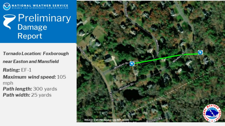
The 25-yard-wide tornado touched down in Foxborough near the Mansfield town line at 8:17 p.m. and lasted for one minute, the service said in a detailed report Sunday night. It traveled west to east for about 300 yards near Windsor Drive and reached a max wind speed of 105 mph.

The service classified the tornado as an EF level 1 tornado — the second weakest tornado level. Some trees, as wide as two feet, snapped at the trunk as a result of the tornado, the service said.
No injuries were reported, but the service said that in nearby Easton, trees came down onto a house and a car. Additionally, two houses suffered structural damage, Easton officials said Sunday.
Another NWS storm survey team was in northeastern Connecticut Sunday to determine if a tornado hit that area Saturday evening, when the service issued multiple tornado warnings.
The service didn’t issue a tornado warning for Easton or Foxborough on Saturday, but did issue one for nearby Brockton and one for areas further east all the way to the coast.
Norfolk, Suffolk, and southern Essex Counties experienced the most rain on Saturday.
Andover and Logan Airport had some of the highest rain totals, with 3.18 inches and 3.07 inches, respectively, according to the service. But areas just north and south of Boston also had rain totals of over 2.5 inches, including Quincy, Milton, Everett, and Saugus.
Boston experienced its fifth wettest July day ever, The Boston Globe reported.
Suffolk County suffered the most flood damage, especially in Boston and Brookline, the service reported. Between 5:15 and 7:15 p.m., Boston police and firefighters reported flooded streets all across the city.
The Boston Fire Department said it received 500 calls within 24 hours on Saturday.
In some areas, manhole covers popped, basements flooded, and cars got stuck in streets, according to the weather service. Part of Storrow Drive was closed for a time, some streets had water levels as high as several feet, and flash floods caused delays on the Green Line.
“When you get heavy rains like that, it’s a lot easier for urban areas to flood,” Pederson said.
Quincy and Lynn were also damaged by flooding, with streets closed due to overflowing water, the service reported.
While Plymouth County didn’t get quite as much rain, it experienced the most wind damage, with the strongest winds blowing through during the 8 o’clock hour, according to the service. Trees and wires were downed all across the South Shore, including in Norfolk County.
“That’s where we had a lot of straight line wind damage come through later in the evening,” Pederson said. “That was the same line of storms that was associated with the EF-1 [tornado] that quickly spun up that evening.”
Easton officials said Sunday that two houses suffered structural damage, and that by 6 p.m., dozens of people in the town were still without power.
A weather pattern impacting the northeast for the last few weeks is causing short but powerful storms. In central Massachusetts and southern New Hampshire, two additional tornados were confirmed in recent days.
“We’ve had a lot of very warm, moist air coming up from the south the last couple of weeks. And then you get a quick cold frontal system that comes through that helps cause some storms to go up,” he said. “When you get a front and then a lot of heat and moisture, that allows these storms to be extra powerful.”
Massachusetts typically sees a few small tornados this time of year due to these weather patterns, Pederson said.
“It’s definitely not unusual to see this happen during the summer, especially in July when this is the typical time of year when you have very hot, humid conditions,” he said.
The northeast should see dryer weather and a break from the storms this coming week, Pederson said.
“There’s really no severe weather that’s standing out in the week,” he said. “We may get some rain towards the end of the week, but as of right now, we’re not too concerned about any severe weather.”
The weather in the Boston area is expected to be sunny and clear with highs in the low 80s and high 70s during the day and upper 50s and low 60s at night, according to the service.
Stay up to date on all the latest news from Boston.com


To comment, please create a screen name in your profile
To comment, please verify your email address
Conversation
This discussion has ended. Please join elsewhere on Boston.com