Here’s how many inches of snow Massachusetts towns got in Saturday’s storm
New England’s first snowstorm of 2017 hit particularly hard in southeastern Massachusetts, where many towns saw well over a foot.
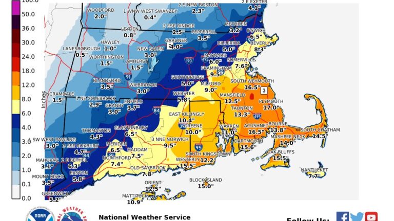
According to the Massachusetts Emergency Management Agency’s estimates late Saturday night, East Bridgewater led all towns with 20.5 inches of powder. Other coastal Bay State towns weren’t far behind:
East Bridgewater, MA: 20.5″
Middleboro, MA: 17.6″
South Weymouth, MA: 16.5″
Carver, MA: 16.5″
Hanson, MA: 15.5″
Marion, MA: 15.0″
South Plymouth, MA: 14.0″
Oak Bluffs, MA: 13.5″
Taunton, MA: 13.3″
West Plymouth, MA: 13.3″
Westport, MA: 13.0″
Bourne, MA: 12.5″
South Yarmouth, MA: 12.5″
Residents captured how those all those inches piled up.
https://twitter.com/jenttelwoh/status/817963819012124672
@fox25news snow fall at noon, 4pm, and 7pm in Bridgewater! pic.twitter.com/nRUjwIgLRi
— TeamJake (@teamjakerides) January 8, 2017
https://www.instagram.com/p/BO_LNomFBbD/
On the Cape and islands, wind gusts measured up over 40 mph, including gusts of 52 mph Saturday night in Nantucket, though the snow never reached official blizzard conditions. The snow made travel treacherous across southern New England nonetheless.
A map from the National Weather Service’s Boston office shows how the snowfall was distributed.
[Final Snowfall Totals] Here is a map of the final snowfall amounts received from yesterday’s Winter Storm. Thank you for all the reports! pic.twitter.com/MUdU3wUXLB
— NWS Boston (@NWSBoston) January 8, 2017
As Massachusetts digs itself out Sunday, with potentially subzero wind chills and a few more inches of snow reportedly on the way, it’s probably best to put on your boots.
https://www.instagram.com/p/BPATGDuhtPN/


To comment, please create a screen name in your profile
To comment, please verify your email address
Conversation
This discussion has ended. Please join elsewhere on Boston.com