So many spotted lanternflies are out right now, you can see it on radar
Many experts have recommended squishing them, but that’s a tall order when there are that many.
All across the region, weather radars were lighting up Thursday with shades of blue, green and yellow. The signals would ordinarily suggest rain — but no precipitation was in the forecast.
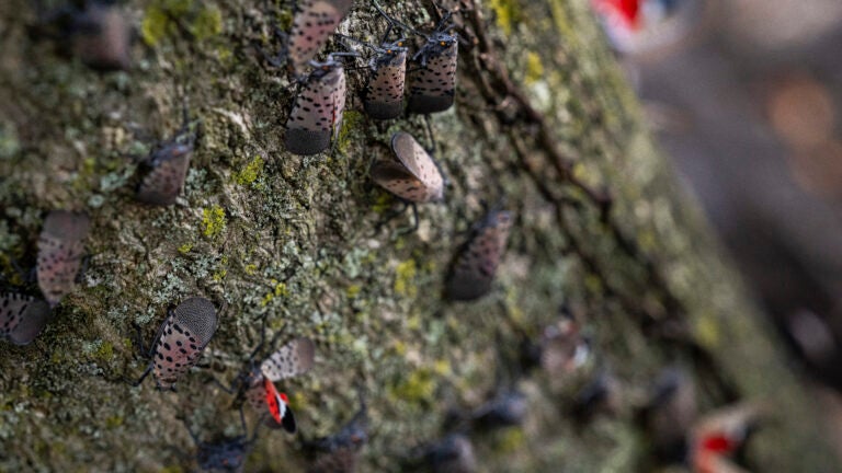
Instead, radars have been capturing a massive swarm of spotted lanternflies descending on the Mid-Atlantic.
The insects are native to Southeast Asia, and are known as a plant hopper species. They can surf air currents — sometimes as high as 3,000 feet. Like other invasive species, they pose a threat to key crops.
Many experts have recommended squishing them, but that’s a tall order — especially when there are enough to appear on weather radar.
How do we know that it’s lanternflies on the radar and not something else? By examining three different types of data.
- Reflectivity mode on radar essentially tells us how much stuff is in the atmosphere. The more cluttered the atmosphere, the brighter a signal. It doesn’t necessarily tell us what is present. But the amount of radar signal being plotted is similar to what we’d see in a moderate rainstorm.
- Correlation coefficient tells us a bit about the shape of whatever’s in the atmosphere. Raindrops are hamburger bun-shaped and snowflakes are snowflake-shaped. But bugs, bats and birds are more spiky and jagged and have low correlation. They might be wider than they are tall, or vice versa. Aside from the obvious fact that it’s not raining, we can tell based on the objects’ shapes that they’re likely biological in nature.
- Velocity helps us deduce which way the objects are moving. On Thursday, objects in the atmosphere over the Mid-Atlantic were moving southward but were also being blown a bit to the east. That suggests they can sort of travel under their own power but are also lightweight enough to be blown by light winds (which doesn’t happen with birds). Plus, birds migrate mostly overnight.
Lastly, we can also see evidence of some convection currents, or basically air currents responsible for distributing heat in the lower atmosphere. We can’t see air or wind on radar, but insects are small enough to act as miniature tracers that we can track.
Insects actually appear on weather radar somewhat regularly. On Oct. 5, 2019, a cold front full of butterflies appeared on weather radars around Oklahoma City.
And during the cicada summer of 2021, there were enough cicadas around the nation’s capital to appear on radar too.


To comment, please create a screen name in your profile
To comment, please verify your email address
Conversation
This discussion has ended. Please join elsewhere on Boston.com