Scenic Route 127 on the North Shore
-

Welcome to Boston.com’s GPS tour of Route 127 from Beverly to Rockport on Boston’s North Shore. Now you can enjoy a real tour from the comfort of your own car. You may download the GPS route to your Garmin, TomTom, or other devices by using the links below. Download options include a guided audio tour of Route 127.
GARMIN:
Audio Tour Guide file for mp3-enabled devices | More Garmin download optionsGOOGLE:
Google Earth file (.kml) | Google Earth softwareTOMTOM:
Download for TomTom, including Go, One, Navigator, and moreMORE GPS TOUR OPTIONS:
Palm, iPod, and more | NO GPS?:
Download pdf of tour -
Independence Park, Beverly

Your first stop will be Independence Park in Beverly. On July 17, 1776, American Colonel John Glover first read the Declaration of Independence to the 14th Continental Regiment that was encamped here to protect the Port of Beverly. Beverly claims to be the birthplace of General Washington’s navy.
GPS coordinates:
Lat: 42.542781
Lon: -70.876911
Closest street address:
41 Lothrop St., Beverly, MA 01915
-
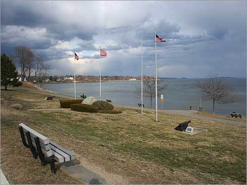
Lynch Park, Beverly

You veer off Route 127 to Lynch Park in Beverly. During the Revolution, a battery of cannons was set up here to disrupt British ships, which had blockaded Boston Harbor. The site eventually became the summer White House for President William Howard Taft. In 1943, the city purchased the land as a park with money bequeathed by leather manufacturer David Lynch.
GPS coordinates:
Lat: 42.547959
Lon: -70.86098
Closest street address:
55 Ober St., Beverly, MA 01915
-
Route 127 scenic vista

Continue North on Route 127 for a bit (and be sure to stay on 127 even if your GPS tries to guide you away). Soon, you come to a nice scenic vista across the street from Endicott College. The college was founded in 1939 and was an all women’s school until the 1990s, when it became co-ed to increase enrollment.
GPS coordinates:
Lat: 42.55078
Lon: -70.839795
Closest street address:
389 Hale St, Beverly, MA 01915
-
Beverly Farms, Beverly

Beverly Farms is one of Beverly’s neighborhoods, known for its village-like charm and wealthy mansions. You may explore the small shopping district before setting off on Route 127 toward Manchester-by-the-Sea.
GPS coordinates:
Lat: 42.562184
Lon: -70.814009
Closest street address:
5 West St., Beverly, MA 01915
-
Downtown Manchester-by-the-Sea

As you continue on Route 127, you will enter Manchester-by-the-Sea. The town features lots of small shops, including book stores, furniture stores, and more. It’s a great stop to just meander, take in the sites, or grab a bit to eat.
GPS coordinates:
Lat: 42.57489
Lon: -70.770117
Closest street address:
5 Beach St., Manchester-by-the-Sea, MA 01944
-
Singing Beach, Manchester-by-the-Sea

A slight detour off Route 127 will take you to Singing Beach in Manchester-by-the-Sea. Singing Beach gets its name from the unusual sand, which has a unique shape, contains silica, and other factors, according to the town website. During the summer, parking is limited and the beach features a refreshment stand.
GPS coordinates:
Lat: 42.570047
Lon: -70.760053
Closest street address:
297 Beach St, Manchester-by-the-Sea, MA 01944
-
Village of Magnolia, Gloucester

After Singing Beach, you return to Route 127 and continue to the village of Magnolia, which is part of Gloucester. Magnolia is a slight detour off Route 127. It also features several nice shops, eateries, and more on nearby Lexington Avenue. It also offers a nice stroll near the water.
GPS coordinates:
Lat: 42.577042
Lon: -70.715126
Closest street address:
30 Raymond St., Gloucester, MA 01930
-
Hammond Castle, Magnolia

Continuing the detour off Route 127, you will pass Hammond Castle. The medieval style castle was built between 1926 and 1929 by John Hays Hammond Jr. as a backdrop for his art collection. The castle is open for tours or functions.
GPS coordinates:
Lat: 42.585215
Lon: -70.693627
Closest street address:
80 Hesperus Ave., Gloucester, MA 01930
-
Stage Fort Park, Gloucester

Stage Fort Park is located on Hough Avenue, which is off Route 127. The park features a picnic cookout area, extensive playground, a small beach, band stand, and a terrific ocean view. It was the site of Gloucester’s first settlement in 1623.
GPS coordinates:
Lat: 42.603729
Lon: -70.679072
Closest street address:
26 Hough Ave., Gloucester, MA 01930
-
Fishermen’s Memorial Statue, Gloucester

The Gloucester boardwalk area on Stacy Boulevard is the site of the Fishermen’s Memorial statue. The statue was erected in 1925 and is made of bronze. It honors the more than thousands of area fishermen who died at sea while trying to support their families.
GPS coordinates:
Lat: 42.610127
Lon: -70.670301
Closest street address:
59 Stacy Boulevard, Gloucester, MA 01930
-
Downtown Gloucester

A short drive away, and just off Route 127, is Main Street in Gloucester. Main Street features even more small shops, and great Italian eateries. If you’re hungry, or need a break from driving, it’s a good location to walk around and see the sites.
Your next stop is Rockport. Your GPS may recommend you stay on Route 127, but we’d recommend Route 127-A (just off 127) as a nicer drive.
GPS coordinates:
Lat: 42.612438
Lon: -70.663505
Closest street address:
122 Main St., Gloucester, MA 01930
-
Bearskin Neck, Rockport

The last stop on the tour is Rockport’s Bearskin Neck. The area is loaded with small craft shops, restaurants, and of course, a nice view of red Motif #1, which is one of the most photographed buildings in the region. Park, and enjoy. Route 128 is a short distance away, and we’d recommend continuing on Route 127 until you reach it.
GPS coordinates:
Lat: 42.659022
Lon: -70.616505
Closest street address:
9 Bearskin Neck, Rockport, MA 01966


To comment, please create a screen name in your profile
To comment, please verify your email address
Conversation
This discussion has ended. Please join elsewhere on Boston.com