The Best Foliage Drives
-

As autumn gears up, jump in the car and take a driving foliage tour to see New England at its brightest.
-
Greater Boston/Merrimack Valley, Massachusetts

Directions: From Boston, take Routes 2 and 4 to Lexington, then Route 2A to Concord’s famous North Bridge (right) and Minute Man statue. From Concord Center, bear left at the fork on Sudbury Road. At the Sudbury line, the road becomes Concord Road and takes you through Sudbury Center and onto US Route 20. Return via US Route 20 through Waltham to Boston.
Round trip distance: ~ 45 miles
When to go: Late October
Drive provided by MassVacation.com. -
Plymouth County,Massachusetts

Directions: Just south of Boston, pick up Route 24 South, then take Route 104 to Bridgewater. Continue on Route 104, then Route 106 to Halifax. Route 58 South will take you to North Carver, where you’ll see cranberry bogs flooded with pools of crimson berries (right) as the harvest gets underway. From North Carver, continue south on Route 58 to Route 28 East to Route 6 West and the towns of Wareham, Rochester, Marion, and Mattapoisett.
Round trip distance: ~ 126 miles
When to go: Late October
Drive provided by MassVacation.com.
-
The Berkshires, Massachusetts

Directions: Follow Route 7 North from Sheffield to Williamstown. Route 8 runs from Sandisfield to Dalton and between two state forests so you’ll get plenty of leaf peeping in early on in the trip. Get on Route 183 and follow the Housatonic River from Great Barrington to Lenox. Take Richmond Road, off Route 183, just south of Tanglewood, and stop at the overlook for views of Stockbridge Bowl and the southern Berkshire Hills. Route 43 East, off Route 7, is the lower road to Williamstown.
Round trip distance: ~ 40 miles
When to go: Late October
Drive provided by MassVacation.com.
-
Acadia Harbors and Heights, Maine

Acadia Harbors and Heights
Directions: Start this tour in Bangor. While here, you can visit the Mount Hope Cemetery, the second oldest garden cemetery in the nation. Travel south toward the coast along Route 1A to Ellsworth, where you can tour Stanwood Homestead Sanctuary, a 130-acre nature preserve. Head south on Route 3 toward Bar Harbor and Acadia National Park (right). Get out of your car and hike up Cadillac Mountain in Acadia for an aerial view of the autumn scenery. From Route 3, take 198 to 102 south to Bass Harbor and then to Southwest Harbor. Head to Somesville along Somes Sound, the only true fjord on the US Atlantic coast, then follow 102 up to 230, and back to Ellsworth. Head south on 172 to Blue Hill. Continue south on 172 to Sedgewick, then west on 175 to Deer Isle Bridge, a suspension bridge over scenic Eggemoggin Reach. Head south on 15 to the quaint fishing villages of Deer Isle and Stonington. Retrace your path up Route 15 to 175 through Bucksport, then continue along Route 15 to Bangor.Round trip distance: ~ 124 miles
When to go: Early to mid-October
Drive provided by www.VisitMaine.com.
-
Downtown Villages and Vistas, Maine

Directions: Begin this tour in Ellsworth and head up Route 1 to West Gouldsboro, then take Route 186 south to Winter Harbor and follow the loop road around the Schoodic Peninsula. This lesser-known part of Acadia National Park is home to granite cliffs with views of Mt. Desert Island. From Winter Harbor, continue on 186 to Prospect Harbor and Gouldsboro, where the Bartlett Estate Winery makes blueberry, apple and pear wines, and offers tasting tours. Continue north on Route 1 to Milbridge and then Cherryfield (right), the “Blueberry Capital of the World.” Continue on Route 1 north then take 187 south to Jonesport and Beals Island, which together make up Maine’s largest lobstering fleet. Head north on 187 back to Route 1 and continue north to Jonesboro, where you can stretch your legs at the pebbles beach of Roque Bluffs State Park. Head east on Route 191 to Route 189 and head for the town of Lubec, where you can explore Quoddy Head State Park. From Lubec, head west on Route 189 to Route 1 in Whiting. Take 1 north to Perry, stopping along the way at Cobscook Bay State Park and the Reversing Falls in Pembroke, where you might be able to spot some seals in the water. From Perry, take Route 190 east to Eastport, the eastern-most city in the nation. Take 190 north back to Perry, then cut over Route 1 south to to 214, then 191 to Baring. From there, head down Route 9 through Wesley and to Beddington. Route 9 continues to Aurora, where you pick up Route 179 back to Ellsworth.
Round trip distance: ~ 200 miles
When to go: Early to mid-October
Drive provided by www.VisitMaine.com.
-
Country Circuit, Maine

Directions: Start your tour in Houlton and take Route 1 through the farming communities of Littleton and Monticello. When you arrive in Mars Hill, take Route 1A to Fort Fairfield, where the Aroostook Valley Country Club’s course is split between Maine and Canada. From there, take 161 to Caribou and take in the 80-mile Fish River chain of rivers and lakes. Continue north taking Route 89 through Limestone, then up 1A to Van Buren. Continue from Van Buren down Route 1 and over to New Sweden, where you can peer over the panoramic views of Canada from the town’s lookouts. Pick up Route 161 north to Madawaska. Next, hop on Route 1 west to Fort Kent, where you change transportation methods and take a canoe trip down the nearby Allagash Wilderness Waterway. From Fort Kent, head south on Route 11 to Eagle Lake then on to Ashland. Pick up Route 163 over to Presque Isle where you can explore Aroostook State Park. Finish this loop by taking Route 1 south, back down to Houlton.
Round trip distance: ~ 196 miles
When to go: Early to mid-October
Drive provided by www.VisitMaine.com.
-
Litchfield Hills, Connecticut

Directions: Begin your tour on Route 7 in Ridgefield. Continue on Route 7 to Danbury’s Main Street. Follow the Housatonic River along Route 7 through New Milford to the village of Kent. Along the way is Bull’s Bridge, one of two covered bridges in Connecticut open to auto traffic. Next, get a view of Connecticut’s highest waterfall at Kent Falls State Park. Follow the Housatonic River (right) along Route 7 to West Cornwall. Take a ride through the classic red covered bridge on Route 128 to the village’s center. Retrace your route back to Ridgefield.
Round trip distance: ~ 96 miles
When to go: Late October
Drive provided by http://www.ctvisit.com.
-
Mystic Country, Connecticut

Directions: Start this tour at Brooklyn’s green. Travel north to the award-winning Sharpe Hill Vineyard and Winery in Pomfret to taste autumn’s wines. Continue to Scranton’s Shops in South Woodstock, where arts, crafts and antiques created by local artisans are housed in an early New England blacksmith shop setting. Continue on to the Woodstock Fairgrounds. Once you’re done leaf peeping, retrace your drive back to Brooklyn.
Round trip distance: ~ 24 miles
When to go: Late October
Drive provided by http://www.ctvisit.com
-
Fairfield County, Connecticut

Directions: The Merritt Parkway’s (Route 15) offers leaf seekers views of scenic farms and villages, starting in Greenwich. Take exit 28 to the Audubon Center, a 295 acre nature sanctuary. Back on the Merritt (right), take exit 35 and turn left onto Route 137 North. Stop by the Bartlett Arboretum, the perfect spot for fall foliage, featuring 91 acres of trails and trees. Continue on to exit 36 heading toward New Canaan. Take exit 45 off the Merritt onto Route 58 North to Easton. Take in the picturesque Aspetuck Reservoir en route to Aspetuck Apple Barn for autumnal food and drink. Turn back onto Route 58 heading south and take a left onto Center Road. Take a left onto Route 59. Stop at Silverman’s Farm to pick your own apples, peaches, or pumpkins. Once you get your fill of fruit, get back on the Merritt and head back to Greenwich.
Round trip distance: ~ 50 miles
When to go: Late October
Drive provided by http://www.ctvisit.com
-
Kancamagus Highway, New Hampshire

Directions: The Kancamagus Highway is a 34-mile parkway that cuts through the heart of the White Mountain region. Start your journey in Conway at the Saco River Station, and head west towards Lincoln. Be sure to take a break at the Rocky Gorge Scenic area to stretch your legs and have a picnic lunch next to the Upper Falls.
Round trip distance: ~ 68 miles
When to go: Mid-October
Drive provided by http://www.nhliving.com
-
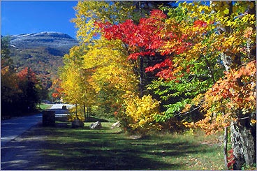
Monadnock Region, New Hampshire

Directions: The Monadnock region of southern New Hampshire offers views of bright, colorful scenery around Mount Monadnock (right). Start your trip in Milford, enjoy Route 101 through Peterborough and into Dublin. Turn right to Harrisville, take Route 137 back to Peterborough and Route 101. To truly make your trip memorable, stretch your legs, get a different view of the foliage, and climb to the summit of Mount Monadnock.
Round trip distance: ~ 56 miles
When to go: Mid-October
Drive provided by http://www.nhliving.com
-
The Lakes Region,New Hampshire

Directions: Start your tour in Meredith on Route 104. Enjoy this village nestled on the banks of Lake Winnipesaukee before resuming travel along Route 25 to Center Harbor. Cruise around Squam Lake to Sandwich, before continuing along Route 25 into Tamworth. Follow the same lake and village filled route back to Meredith.
Round trip distance: ~ 44 miles
When to go: Mid-October
Drive provided by http://www.nhliving.com
-
Upper Connecticut River Valley, Vermont

Directions: Start your tour on Route 4 in Woodstock and travel east to Taftsville. Continue on to Route 12 to Hartland, where you can explore routes to some of the town’s many waterfalls. Next, turn on to Route 5 and proceed to Windsor. In Windsor take Route 44 west through Brownsville to the junction with Route 106. Take Route 106 south to Felchville. Follow Tyson Road west through South Reading to Tyson. Enjoy Route 100 north from Tyson through Plymouth Union, where you can visit the Calvin Coolidge Birthplace. Continue on Route 100 to West Bridgewater, Sherburne Center, Pittsfield, Stockbridge, Talcville and Rochester. In Rochester, travel east to Route 12 toward Randolph. Travel east on Route 66 through Randolph Center to East Randolph. At the intersection of Routes 66 and 14 turn right, then almost immediately left onto Chelsea Road, Angel Road, Dickerman Road from East Randolph to Route 110. Turn south on Route 110 through North Tunbridge to Tunbridge. Go east on Strafford Road, from Tunbridge through Strafford and to South Strafford. In South Strafford take Route 132 west to Sharon. Take Howe Hill Road, south from Sharon through Hewitts Corners, on to Pomfret Road and through South Pomfret to Route 12 and into Woodstock.Round trip distance: ~130 miles
When to go: Early to mid-October
Drive provided by www.VermontVacation.com
-
Stowe and Northern Mountains, Vermont

Directions: Start your leaf viewing in Stowe, where you can take in the views of Moss Glen & Bingham Falls. Travel north on Route 100 then take left fork on to the Stagecoach Road. Turn left at the stop sign on to French Hill Road and follow it to a right turn on to White Road. Travel into Johnson on Railroad Street to the intersection with Route 15. Turn right here and go past the junction of Routes 100 and 15. Pick up Route 100. Turn left onto Greaves Hill Road, then left on to Couchaine Farm Road, and take it to Route 15. Take the first left on Route 15 to West Hill Road. Next, turn right on to North Wolcott Road and go 8 miles, turn left just past cemetery to Gulf sign, and left again 7 miles to Eden Mills. In Eden Mills turn left onto Route 100, go about 1 mile then turn right onto Route 118; follow it to intersection with Route 109 in Belvidere Corners and take Route 109 west through Belvidere Center to Waterville. Take the second left on to unpaved Hogback Road And follow it to intersection with Route 15. Take a sharp right onto Route 15 and follow it through Cambridge Junction, Jeffersonville, Cambridge and into Underhill Flats. Turn left on to unpaved River Road, then take the third left on to Pleasant Valley Road and follow it about 10 miles, and take the Upper Valley Road to Jeffersonville and intersection with Route 108. Turn right on to Route 108 and enjoy the last 18 miles before returning to Stowe.
Round trip distance: ~125 miles
When to go: Early to mid-October
Drive provided by www.VermontVacation.com.
-
Western Counties, Vermont

Directions: Travel Route 4 east through Mendon, Killington, and West Bridgewater to Bridgewater Corners. In Bridgewater Corners take Route 100A to Route 100 south to the junction with Route 103. Take Route 103 west through Healdville and Bowlsville to East Wallingford then take Route 140 west to Wallingford. From Wallingford take Route 7 south to Danby, then take Bon Hill Road West from Danby to Pawlet. Follow Route 30 north through Hubbardton. About 7 miles north of Hubbardton take a right on to St. John’s Road, then Burr Pond road, then Long Swamp Road into Brandon. Take Route 7 to Proctor and Route 3 South from Proctor to Center Rutland, and 4B into Rutland City .
Round trip distance: ~130 miles
When to go: Early to mid-October
Drive provided by www.VermontVacation.com.
-
Ocean Drive in Newport, Rhode Island

Directions: Before driving out of Newport (right), take in the fall foliage of Fort Adams State Park. Once your on the road, take Route 138 East across the Jamestown Verrazano Bridge, across Jamestown Island, and then across the Claiborne Pell Bridge into Newport. Exit the bridge to the right. Follow Farewell Street to America’s Cup Avenue through the downtown. America’s Cup Avenue turns into Thames Street and Thames Street turns into Carroll Avenue. At the end of Carroll Avenue, turn right onto Ocean Drive. Ocean Avenue loops around the perimeter of the tip of the island, returning to rejoin Thames Street.
When to go: Late October
Drive provided by www.visitrhodeisland.com
-
Scituate Loop, Rhode Island

Directions: Begin on I-295 and take Exit 4 to Route 14 West. Go through the intersection with Route 116. You will pass over part of the reservoir and then into the pretty town of Scituate. Make a stop at the Pippin Orchard to for fall foliage and food. Continue on Route 14 out of town and then turn left onto Route 12. This will take you across the Hope Dam. At Route 116 turn left, traveling north. At Route 14 turn right and retrace your drive back to I-295.
When to go: Late October
Drive provided by www.visitrhodeisland.com
-
The Coastline, Rhode Island

Directions: Start your tour in Westerly by taking I-95 to exit 92 in Connecticut. While here, stretch your legs with a walk on Misquamicut Beach. Follow Route 2 south of West Broad Street in Pawcatuck.Turn left onto Broad Street and cross the Pawcatuck River. Follow signs for Route 1A through Westerly, and along the shoreline. The route will bring you through a number of communities, including Misquamicut, Charlestown, Wakefield, Narragansett, Saunderstown, and into Wickford. Of all the towns, schedule to spend the most time in Charlestown, where you can visit Burlingame State Park, Ninigret Pond, and the Fantastic Umbrella Factory.
Round trip distance: ~ 66 miles
When to go: Late October
Drive provided by www.visitrhodeisland.com
-

-

-


To comment, please create a screen name in your profile
To comment, please verify your email address
Conversation
This discussion has ended. Please join elsewhere on Boston.com