Travel to remote Seguin Island and its historic light station
SEGUIN ISLAND — It’s a clear, calm day. The Leeward bobs in the water where the deep Kennebec River meets the Atlantic Ocean in midcoast Maine. The open-air boat chugs forward slowly, its driver careful to keep his two dozen passengers from jostling too much in the bulky swells punctuated by seal-draped ledges.
Driver Ethan DeBery resembles a casual surfer dude, but talk to him at any length and you discover that not only is he a certified and licensed master captain, but he also knows these waters. Son of a fisherman, he grew up in Phippsburg, a town comprising most of the peninsulas you see from the boat. This stretch of comingling, sometimes dangerous currents has been his highway for all of his 30 years. And he is no risk-taker. “We’ve turned around quite a few times,’’ he said.
In 2010 he started ferrying visitors on the Leeward from Fort Popham to Seguin Island, 2½ miles off shore, home to Seguin Island Light Station. Commissioned by President Washington, Seguin is Maine’s second oldest lighthouse and its highest above sea level, a landmark along this coast. The ferry leaves five days a week from the Civil War-era fort about a mile and a half from Popham Beach State Park.
It is low tide when a friend and I take the trip, which means that rather than walk a gangplank to board, we descend a vertical ladder. DeBery and his mate pass down canvas bags and backpacks.
On our boat are Victor Hart from Round Pond and his wife, child, and grandchildren. A group from Pennsylvania, all new to Maine, are along for the ride, as is Wendy Wilkes from Ann Arbor, Mich., who has never before visited a New England island. Jennifer Krier from Belmont, Mass., is repeating the trip; she remembers visiting Seguin by private boat about 20 years ago.
Also with us are one gentleman who was nervous about taking his own vessel through the choppy stretch, and another passenger interested in the 1607 Popham Colony who wanted to see what the English encountered when they first came upon land. “Rock doesn’t change,’’ he said.
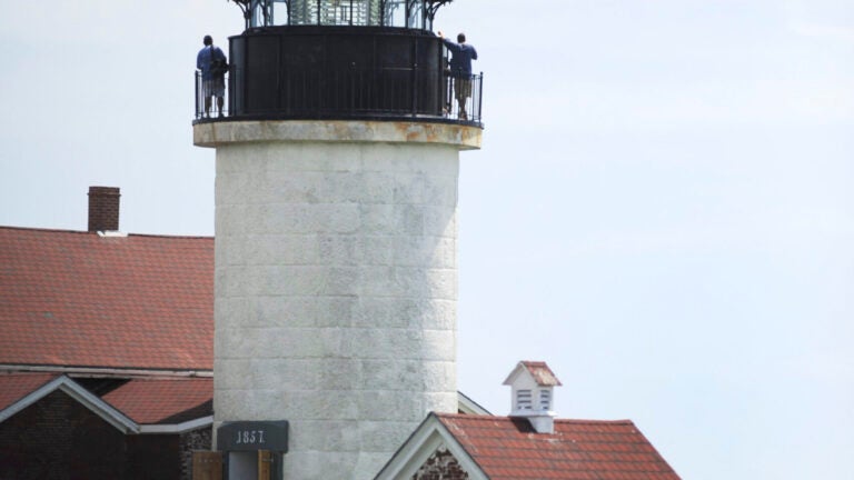
The island looms large as we approach. DeBery navigates the Leeward into a cove with a rock-strewn beach, the only safe spot to land on this 64-acre outpost. Imposing rocky cliffs border one side of the beach; on the other is a 1,000-foot wooden tramway still used to bring supplies from boat to keeper’s house.
Mooring buoys dot the cove. Most of these are available to private boaters who venture here on their own. In 2011, this island, owned by and under the stewardship of the nonprofit group Friends of Seguin Island Light Station (FOSIL), was added to the Maine Island Trail. Visitors are not only welcome but encouraged.
DeBery’s rubber dinghy takes four to five people at a time from the moored Leeward to dry land. Ankles get splashed upon stepping onto the beach — all part of the adventure.
Nate Power, 28, caretaker of the island last season, greets our group at the water’s edge. (Most visitors walk the hill to the lighthouse unescorted.) While the US Coast Guard monitors the Seguin light, foghorn, and island power source, FOSIL takes care of the tower, keeper’s house, moorings, and grounds. The group also hires the caretaker, who is almost always on hand to lead tours of the lighthouse.
Power has been volunteering on the island since 1991. For his Eagle Scout project he installed a composting toilet here. Before getting his first assignment upon graduation from Maine Maritime Academy in 2011, he took the job of caretaker. His then-girlfriend (now wife), Amy Power, joined him, never having seen the keeper’s quarters she would be living in for three months.
The only technology the pair has on the island is their cellphones, and even those are spotty. But the couple is far from unhappy. Nate: “It’s hard to say we’re volunteering with a straight face when all we do is give tours and meet the boats.’’
(That’s not entirely true. He mows the grass, tends a vegetable garden, keeps supplies stocked, monitors the underwater cable that brings electricity to the island, and is in radio touch with the Coast Guard. Twice on his watch a Guard contingent out of Cape Cod dropped in by helicopter to check on things.)
A walk up the hilly path bordered by raspberry vines and rose hip bushes lands us at the top of the island, where the lighthouse and keeper’s quarters stand central on grassy turf.
The spot is perfect for a picnic, but you will have to bring your own. There are no concessions on the island.
Hiking trails cross the varied landscape, making it a great place to explore. Power leads us up the spiral staircase to the catwalk of the signal tower, 186 feet above sea level, where we get expansive and dramatic views in all directions. From this perch one can see the irregular Maine coastline, fishing and recreational boats, the mouth of the deep Kennebec River, Monhegan Island, and on a very clear day, the summit of Mount Washington.
A signal has operated on the island since 1796, Power tells us. The island’s five buildings are on the National Register of Historic Places. The Friends organization fought to keep the first-order Fresnel lens, worth $8 million some say, on site, and this gargantuan lens — 9 feet tall and 6 feet in diameter and made of 282 glass prisms — is the only one north of Virginia still operating. It was installed in 1857, and its fixed light beam can be seen for 20 nautical miles.
Over time, the Friends have uncovered much about the island’s past. In the early part of the 20th century, Seguin Island was a small community with livestock, gardens, and three families with several children. Last summer, members unearthed a giant brick arrow marking magnetic north, a navigation aid for air travelers. The group continues to search for and dig up other old sites, including the blacksmith shop and the foundation of the original 1796 wooden tower.
A small museum of historic photos and artifacts occupies one side of the keeper’s house, and Amy Power is here to answer visitors’ many questions. She sells us a trail map for a dollar before we set out for a hike. She also shows us the spare apartment on the second floor, available to Friends who wish to stay overnight.
After three hours, visitors walk downhill to the cove where the Leeward awaits. The views, the light, the aura — they are different as we head for home. As are we. We are in no hurry. The serenity of this offshore island and a sense of Maine’s maritime history stay with us as we motor to land and continue on our way.


To comment, please create a screen name in your profile
To comment, please verify your email address
Conversation
This discussion has ended. Please join elsewhere on Boston.com