Sign up for the Today newsletter
Get everything you need to know to start your day, delivered right to your inbox every morning.
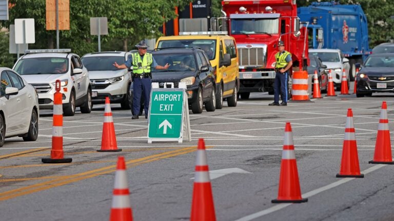
In a city with traffic due to tunnel closures and changing commutes, it’s important to know the fastest way to your destination. But which app does it best?
Twitter account Apple Hub asked its followers Wednesday which map app they prefer — Apple Maps or Google Maps? The tweet generated intense debate on social media, with thousands of users defending the two apps. Some decided to introduce Waze as a third competitor.
Over 200 readers responded to our poll asking if they preferred Apple Maps, Google Maps or Waze. The winner was clear — Waze took the cake receiving around 59.1% of the total vote.
One appeal of Waze is its community reporting feature, where users can warn others of upcoming traffic or obstacles.
“Waze offers real-time traffic, cops ahead, obstruction in road, etc.,” said reader Scott T. from Saugus. “It will reroute you to shortest travel as well. Great app.”
Regardless of their app of choice, many readers shared stories of when using a navigation app went awry. For example, Google Maps sent reader Matt S. from Hubbardston on an interesting route while visiting his sister.
“I was using Google Maps several years ago to visit my sister in East Sandwich. It brought me down a dead-end road, onto a dirt road under high-power lines and through someone’s driveway. Definitely the wrong route,” Matt S. said.
Reader J.R. from Somerville had an aquatic experience with Apple Maps while trying to get to a concert.
“Apple Maps almost sent me into Boston Harbor trying to get to a [Leader Bank] pavilion show years ago,” he said.
Below are some reasons why Boston.com readers chose their favorite app and their stories about navigation apps gone wrong.
Some responses have been edited for length or clarity.
“We have a saying — Always. Trust. Waze. Even when I think it’s wrong, I find out it was right after all. The real time traffic information is the key. It literally has never sent me the wrong way or the lesser of options. It knows when to use the upper or lower [George Washington] Bridge lanes if you’re trying to get through New York. It has had me get off I-93 in New Hampshire to bypass one exit where a crash had just blocked the highway and I would have had a huge delay. The best part is the more people who use it, the better information it has. I really don’t know why one would use anything else.” — Hugo, Jamaica Plain
“While the design is a bit goofy and simplistic, it has the best advanced traffic/accident alerts and rerouting.” — Andrew E., Chatham
“Focus on commuting through social reporting, alternative route selection and map error flagging and community map fixing.” — Rita G., Issaquah Highlands, Wa.
“Easy directions with real-time traffic updates, construction, police, delays, etc. Super easy to update in real time. It’s also fun competition as the app rewards users with points for longevity of use, marking things on the map (e.g. traffic, police, construction, vehicle pulled over, potholes, weather, etc.). I’ve used it exclusively for five years and will never change.” — Matt S. Hubbardston
“Directions are great, time for arrivals are accurate and provide traffic issues; delays, road hazards, and police locations.” — Bill H., Las Vegas, Nv.
“Real time data on traffic and police. Tends to be more logical routes.” — J.P. H., Bolton
“Notifies of police location, potholes, cars on the side of the road, even roadkill.” — Erik L., Shrewsbury
“User interactive, warns about things like heavy traffic, speed traps, accidents, cars parked on the side of the road, etc., as well as has pictures of parking lots/buildings which is nice for people who have anxiety when it comes to knowing where to park or where to enter a building.” — Joe, Syracuse, N.Y.
“Clear view of streets, business landmarks are especially helpful when visiting or searching for a new place. Ability to print out the maps, showing nearby areas a plus. We save the printed maps for the next trip to that location.” — Margaret, Hudson, N.H.
“I feel like it gets me to my destination fastest.” — Valerie F., Sudbury
“Direct routes; useful options to avoid highways; updated traffic conditions with updated faster options; knows road closures and detours.” — Mary Ann R., Weston
“That being said, I use Google Maps when planning out a trip to see the different routes ahead of time (and also when traveling by public transit).” — Jen, Waltham
“I find it to have the most updated/accurate information and have not had any issues with it routing me via unsafe/unrealistic routes. I especially find it helpful when I am traveling internationally.” — V.C., Dracut
“It consistently gives the fastest routes and suggests quicker routes when available and make sense.” — David, Marlborough
“I was a Waze girl for the longest time. Gamifying my experience, and getting a crown for being top user — loved it. I recently switched to Apple Maps, by accident really. Apple Maps is like driving with your friend — ‘not this set of lights, but the next set of lights, take a right.’ It could use a bit more in the self-reporting area which is something I love about Waze but with Apple Maps I am never trying to do visual measurements of what 1,000 feet is.” — Kate D., Everett
“Ease of use. They are all tools, and you have to know when to use your own judgment.” — Penelope W., Worcester
“Apple CarPlay and Siri, just works.” — John G., Raymond, N.H.
“Better user experience and better graphics.” — Tom, Essex
“Waze has many times sent me through some random tiny town in attempt to be faster, but the result is usually the opposite.” — David, Marlborough
“Once in Palm Coast, it took me to an apartment complex versus Michael’s craft store. Only glitch so far.” — Jane, Palm Coast, Fl.
“In Twin Falls, Idaho, I was looking for a playground to take my brother’s grandson; it took me to a town about 20 miles outside of Twin Falls that was in farmland.” — Joe F., Attleboro
“Kansas City. The exits of the interstates are so close together downtown that every single one was passed when we got the direction to take the exit. That was using Google Maps.” — Paul Z., Malden
“Apple Maps doesn’t show my street more than three years since it was named.” — S.S., Westchester County, N.Y.
“For whatever reason Apple Maps had my location nowhere near correct as it was trying to guide me. It showed me that the little arrow was moving, signifying that I was in fact driving, but it wasn’t tracking my location in the slightest. I panicked as I tried to reload the app while driving several times, but it did the same thing every time. Finally, I pulled into a parking lot in an area that didn’t exactly seem the safest, but I only stayed long enough to open up Google Maps which did eventually get me home.” — Joe, Syracuse, N.Y.
Boston.com occasionally interacts with readers by conducting informal polls and surveys. These results should be read as an unscientific gauge of readers’ opinion.
Get everything you need to know to start your day, delivered right to your inbox every morning.


Be civil. Be kind.
Read our full community guidelines.To comment, please create a screen name in your profile
To comment, please verify your email address