Facelift in the Works for Dorchester’s Mt. Vernon Street
As Dorchester undergoes a building boom largely driven by the expansion of UMass Boston’s campus, Mt. Vernon Street in Columbia Point could be getting a makeover that aims to put pedestrians and bicyclists on “equal footing’’ with motorists.
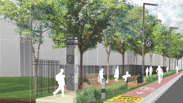
The Boston Redevelopment Authority, in tandem with consultants from transportation engineering company McMahon Associates and urban design firm Crosby Schlessinger Smallridge LLC, unveiled a preliminary design for the project at a public meeting on Tuesday, March 10. BRA planners and project consultants said they have designed a “functional, yet beautiful’’ street that will have safer accommodations for bicycling, walking, and automobile traffic in Columbia Point.
The city proposal reflects the guidelines of the ‘Boston Complete Streets’ initiative that was launched in 2009 as a way for the city to create safer and more efficient streets. The remodeled street will feature wider sidewalks for pedestrians, as well as a protected bike lane at the sidewalk level near the curb. The space between the sidewalk and the bike lane will be landscaped with trees and green space.
The redesign will complement work being done as part of UMass Boston’s 25-Year Campus Master Plan, said Tad Read, a BRA senior planner on the Mt. Vernon Street project.
UMass Boston has been working on its master plan to accommodate 25,000 students (up from 15,000) in the Columbia Point area since 2009. The campus planners envision a transit-oriented community with more than just dorms. They imagine homes, offices, shops, restaurants, hotels, and wide, tree-lined streets. An extensive system of new bike paths would also improve connections to the adjacent Dorchester and South Boston neighborhoods and the waterfront.
“UMass encourages students to use bicycles, use public transit, and walk,’’ Read said. “There are, and will be in the future, a lot more walkers and bikers along that street.’’
Construction is well underway at UMass.
On March 31, the $79 million Edward M. Kennedy Institute for the United States Senate, located on UMass Boston’s campus, opens to the public. And the 200 Mt. Vernon St. Bayside Expo Center, a convention center purchased by UMass in 2010, will be demolished by April 2015 and converted into 600 parking spaces for students and faculty.
In addition to the anticipated influx of UMass students to Columbia Point, Mt. Vernon Street is a good candidate for redesign, because the street is currently constrained by spots of daily traffic congestion at Kosciuszko Circle, Interstate 93 access ramps, and the intersection with Morrissey Boulevard, Read said.
“Kosciuszko Circle was designed as part of the Emerald Necklace, as a parkway, not designed to handle a lot of traffic,’’ Read said. “That traffic circle is handling a lot more traffic than it should, and it is not handling it effectively.’’ Traffic from the circle causes back-ups on Mt. Vernon, Read added.
With the redesign, Mt. Vernon Street will maintain its current number of traffic lanes, Read said: four vehicular travel lanes at Morrissey Boulevard where car traffic is generally heaviest, and two lanes where traffic is lighter, with one in each direction. But to help mitigate current traffic congestion, new traffic signal technologies will be installed to help the city process the traffic far more efficiently, Read added.
Launched in 2009 by the Boston Transportation Department, The Boston Complete Streets program established new guidelines for street design and renovation projects, with a focus on making streets bike and pedestrian friendly (“multimodal’’ in the urban design community), environmentally friendly, and equipped with digital information infrastructure to provide real-time traffic data to the city.
Under the initiative, some planned projects include Audubon Circle in Fenway, Central Square in East Boston, Boylston Street in Fenway, and Rutherford Avenue in Charlestown, among others.
“The Mount Vernon Street plan creates safe avenues for multi-modal transportation and beautifies the streetscape, so that it’s much more welcoming for residents and visitors,’’ Mayor Marty Walsh told the BRA, adding that investing in protected bike lanes is “crucial to elevating Boston as a cycling city on a global scale.’’
Many cities all over the world are making a concerted effort to improve street design for multimodal transportation. London, one of Europe’s most congested cities, recently proposed a four-lane elevated bikeway over the Thames River. And in Copenhagen, where 50 percent of the country’s population rides a bike to school or work, an elevated 721-foot bikeway called “Cykelslangen,’’ or Cycle Snake was constructed over the city’s harbor to ease congestion.
The Mt. Vernon Street design unveiled March 10 was only the first step of the design process, Read said. The BRA is now undertaking a second study to “flesh out further details’’ and secure funding from the city. He anticipates the design to move into its “100 percent’’ design phase some time next year, when detailed engineering drawings are prepared for construction, which could take two to three years.
In addition to the BRA, the Boston Public Works Department, the Boston Transportation Department, the Boston Water & Sewer Commission, the Parks Department, and the State Department of Conservation and Recreation are overseeing the project, which is estimated to cost several million dollars.


To comment, please create a screen name in your profile
To comment, please verify your email address
Conversation
This discussion has ended. Please join elsewhere on Boston.com